

Almtal trail


- Flatly
Interactive elevation profile
Create PDF
Tour-Details
Starting place: 4644 Scharnstein
Destination: 4644 Scharnstein
duration: 2h 45m
length: 10,8 km
Altitude difference (uphill): 88m
Altitude difference (downhill): 82m
Lowest point: 504m
Highest point: 555m
difficulty: medium
condition: medium
panoramic view: Individual Views
Paths covering:
snow
powered by TOURDATA
Trail not in operation
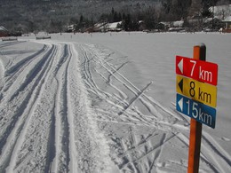
Cross-country skiing in the Almtal - Discover the beautiful landscape of Scharnstein while cross-country skiing on the fantastically groomed cross-country ski trails.In the attractive network of trails with trails of various lengths and levels of difficulty, both beginners and cross-country skiing pros will find the right track here.
Almegg-Loipe: The 12 km long, moderately difficult trail leads across meadows and along the edges of the forest in one round back to the starting point.
The trail leads to the edge of the forest to the district of Fischerbühel, further across meadows and along the edge of the forest to the Hauergrabenbach stream in Almegg. From there in one round back to the starting point
We ask you to stick to the running direction and keep the trail clean. Please note the "No Dogs" signs. Help us maintain and maintain the trail with a donation. You can donate to the savings boxes that are set up and thus become a "sponsor of the Almtal cross-country ski trail".
Parking
- Parking space: 40
Payment methods
Other payment methods
Cash payment
- Suitable for friends
- Suitable for children
- Deep winter
Please get in touch for more information.
Im Dorf 17
4644 Scharnstein
Phone +43 7616 8268
E-Mail almtal@traunsee-almtal.at
Web www.traunsee-almtal.at
https://www.traunsee-almtal.at
You can also visit us on
Visit us on FacebookInteractive elevation profile
Create PDF
Tour-Details
Starting place: 4644 Scharnstein
Destination: 4644 Scharnstein
duration: 2h 45m
length: 10,8 km
Altitude difference (uphill): 88m
Altitude difference (downhill): 82m
Lowest point: 504m
Highest point: 555m
difficulty: medium
condition: medium
panoramic view: Individual Views
Paths covering:
snow
powered by TOURDATA