

Rennradtour Einführungsrunde


- Flatly
- Possible accommodation
Interactive elevation profile
Create PDF
Tour-Details
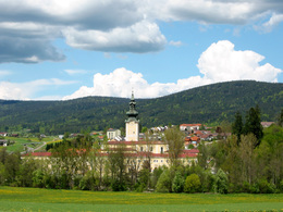
Starting place: 4160 Aigen-Schlägl
Destination: 4160 Aigen-Schlägl
duration: 3h 0m
length: 43,0 km
Altitude difference (uphill): 851m
Altitude difference (downhill): 846m
Lowest point: 484m
Highest point: 766m
difficulty: easy
condition: easy
panoramic view: Great panorama
Paths covering:
Asphalt
powered by TOURDATA
Easy introductory lap for racing cyclists.
0 km This tour starts in Aigen-Schlägl. Leave the market square in a southerly direction downhill, past Schlägl Abbey and leave the roundabout in the direction of Rohrbach. After crossing the railway tracks, keep left uphill towards Weichsberg. From here, the route climbs steadily through Kollonödt to Andexling. From here, continue downhill to
8 km Fürling. Turn left and continue via Sexling and Hundbrenning onto Obere Felberaustraße with wonderful views of Haslach. Continue to Nößlbach and turn left onto the main road. After a short stretch, turn right towards the railway station. Shortly before the railway station, turn left, cross the bridge and follow the road along
the Große Mühl to
20 km Iglbach. Cross the bridge and after a short climb you will reach Etzerreit. Approx. 500 metres after the village, turn right towards Wippling. Your tour takes you through smaller villages to
27 km Gollner. Cross the main road, along Stifterstraße and Hofmark you cycle along the southern slope of Maria Trost Berg with wonderful views of Rohrbach-Berg, Bahnhofstraße takes you out of town. At the end of the town centre, turn right and follow the road via Hehenberg towards Öpping. A short stretch to the right along the main road takes you to
34 km Öpping. From here, the route climbs steadily uphill. The tour takes you through Haugsberg and Oberneudorf to St. Wolfgang. Follow the road downhill and enjoy the beautiful views of your starting point
43 km Aigen-Schlägl.
Use the free outdooractive app to navigate the route.
Most economical season
- Spring
- Summer
- Autumn
Please get in touch for more information.
Hauptstraße 2
4160 Aigen-Schlägl
Phone +43 5 7890 - 100
Fax machine +43 5 7890 - 115
E-Mail info@boehmerwald.at
Web www.boehmerwald.at
Web www.almesberger.at
https://www.boehmerwald.at
https://www.almesberger.at
https://www.almesberger.at
You can also visit us on
Visit us on Facebook Visit us on Instagram Visit our videochannel on YouTube")
Interactive elevation profile
Create PDF
Tour-Details
Starting place: 4160 Aigen-Schlägl
Destination: 4160 Aigen-Schlägl
duration: 3h 0m
length: 43,0 km
Altitude difference (uphill): 851m
Altitude difference (downhill): 846m
Lowest point: 484m
Highest point: 766m
difficulty: easy
condition: easy
panoramic view: Great panorama
Paths covering:
Asphalt
powered by TOURDATA