

Gemeindevideo Pfaffstätt
Pfaffstätt, Oberösterreich, Österreich
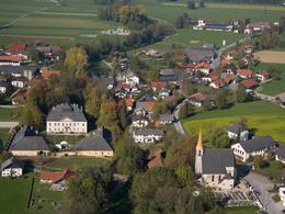


The municipality of Pfaffstätt
The village is one of the oldest in the Mattig valley and its history can be traced back to Celtic times. During the Ice Age, tributaries of the Salzach glacier extended into the Mattig and Schwemmbach valleys and deposited gravel mountains (moraines) here. The hill on which Pfaffstätt lies and also the Siedelberg are such gravel deposits. In the Later Stone Age - around 7000 years ago - people colonised the banks of these valleys, as they offered an abundance of fish and game and were easier to access by road. The rest of the area was covered with impenetrable primeval forest. The Celts fortified their "houses" on today's Burgstall with three ramparts to the west, while the steeply sloping hill protected them on the other sides. The ramparts are still clearly visible today and were built artificially. There is evidence that iron tools were already being made on the Siedelberg at this time. So-called "racing furnaces" were built to extract this iron. These furnaces were sunk up to 60 metres deep into the ground. In 15 BC, the Celtic kingdom of Noricum fell to the Roman Empire. The Romans were masters at building roads and bridges and are also said to have built a Roman road to Mattighofen through Pfaffstätt - coming from Pfaffing. After the Romans withdrew, the Huns invaded the area around the year 500 and devastated it. Some time later, the Bavarians occupied the land and fortified the borders against raids by the Magyars. In 796, disciples of St. Rupert of Salzburg came to the area to Christianise it. A baptismal church was built on the Mattig. In this year, the name "Paphstetti" is also mentioned for the first time in a document from the diocese of Passau. After 1800, the village of Sollern near Pfaffstätt was mentioned in a document from Michaelbeuern Abbey - as the noble residence of a certain Adam Walfinger with the name "Niedersalheern".
Pfaffstätt has been a separate municipality since 17 March 1908. With the law of 25 February 1908, His Majesty Franz Joseph ordered the separation of the local community of Kirchberg into two independent communities "Kirchberg" and "Pfaffstätt". Until then, the municipal office was housed in the "Gmoastubn" in Siegertsgaft. The first mayor was Josef Buchner, Friedlbauer. He had already been mayor of Kirchberg from 1903 to 1906.
Today, Pfaffstätt has 1080 inhabitants and an area of 918 hectares. The municipality consists of six villages: Pfaffstätt, Erlach, Fludau, Kitzing, Kuglberg and Sollern. The highest elevation is the Siedelberg (541 metres). The municipality lies at an altitude of 465 metres above sea level.
Please get in touch for more information.
Contact
5230 Pfaffstätt
Phone +43 7742 2355 - 0
Fax machine +43 7742 2355 - 7
E-Mail gemeinde@pfaffstaett.ooe.gv.at
Web www.pfaffstaett.ooe.gv.at
http://www.pfaffstaett.ooe.gv.at
powered by TOURDATA