

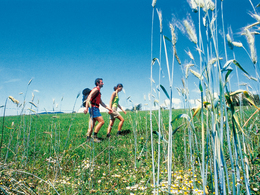
Kreuzweg


- Suitable for families
Interactive elevation profile
Create PDF
Tour-Details
Starting place: 5252 Aspach
Destination: 5252 Aspach
duration: 0h 58m
length: 3,6 km
Altitude difference (uphill): 48m
Altitude difference (downhill): 54m
Lowest point: 423m
Highest point: 472m
difficulty: medium
condition: medium
panoramic view: Some Views
Paths covering:
Asphalt, Hiking trail
powered by TOURDATA
From the Kneipp spa house to the main road - left to the Danzer inn - right on the Aspach/Rossbach road - Pimberg - Binder chapel (resting bench with good panoramic view) - to the sharp right bend - turn left - straight ahead to the Höhenweg road - Kreuzweg (resting bench at the wayside cross) - continue to the Oberinnviertler Landesstraße road - turn left towards Aspach - over the newly built bike and hiking trail to Aspach
- Suitable for seniors
- Suitable for single travelers
- Suitable for friends
- Suitable for children
- Spring
- Summer
- Autumn
- Early winter
Please get in touch for more information.
5252 Aspach
Phone +43 7755 7355
Fax machine +43 7755 7355 - 4
E-Mail info@aspach.at
Web www.aspach.at
http://www.aspach.at
Interactive elevation profile
Create PDF
Tour-Details
Starting place: 5252 Aspach
Destination: 5252 Aspach
duration: 0h 58m
length: 3,6 km
Altitude difference (uphill): 48m
Altitude difference (downhill): 54m
Lowest point: 423m
Highest point: 472m
difficulty: medium
condition: medium
panoramic view: Some Views
Paths covering:
Asphalt, Hiking trail
powered by TOURDATA