

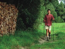
Ferdinand-Arbinger-Weg


- Suitable for families
- Suitable for kids (all ages)
- Flatly
Interactive elevation profile
Create PDF
Tour-Details
Starting place: 5252 Aspach
Destination: 5252 Aspach
duration: 0h 25m
length: 1,7 km
Altitude difference (uphill): 8m
Altitude difference (downhill): 8m
Lowest point: 424m
Highest point: 438m
difficulty: easy
condition: easy
panoramic view: No view
Paths covering:
Hiking trail
powered by TOURDATA
A peaceful path, no slope. Pass the parking lot of the spa house to settlement - in the south-western part turnoff on a meadow path - along the Niederhamer brook - at the big oak turn right to the main road - town center - spa house.
- Suitable for kids (all ages)
- Suitable for seniors
- Suitable for single travelers
- Suitable for friends
- Spring
- Summer
- Autumn
Please get in touch for more information.
5252 Aspach
Phone +43 7755 7355
Fax machine +42 7755 7355 - 4
E-Mail info@aspach.at
Web www.aspach.at
http://www.aspach.at
Interactive elevation profile
Create PDF
Tour-Details
Starting place: 5252 Aspach
Destination: 5252 Aspach
duration: 0h 25m
length: 1,7 km
Altitude difference (uphill): 8m
Altitude difference (downhill): 8m
Lowest point: 424m
Highest point: 438m
difficulty: easy
condition: easy
panoramic view: No view
Paths covering:
Hiking trail
powered by TOURDATA