

Nr. 317 1000 jährige Linde


- Suitable for families
Interactive elevation profile
Create PDF
Tour-Details
Starting place: 5241 Maria Schmolln
Destination: 5241 Maria Schmolln
duration: 4h 1m
length: 13,4 km
Altitude difference (uphill): 364m
Altitude difference (downhill): 364m
Lowest point: 486m
Highest point: 629m
difficulty: medium
condition: medium
panoramic view: Individual Views
Paths covering:
Hiking trail
powered by TOURDATA
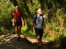
town square - Unterminathal - Minathaler path - left in the direction of Erlinger - up Totenmann hill - cross the main road - left to power station 1 - up to the 1000-year-old lime tree - through the forest - down into Moosbachtal - cross the main road - road Raucheneck - through the forest and meadow path back into the valley - along the edge of the forest to the road to Maria Schmolln
- Suitable for groups
- Suitable for friends
- Spring
- Summer
- Autumn
- Early winter
Please get in touch for more information.
5241 Maria Schmolln
Phone +43 7743 2255
Fax machine +43 7743 2255 - 4
E-Mail gemeinde@maria-schmolln.at
Web www.maria-schmolln.at
http://www.maria-schmolln.at
Interactive elevation profile
Create PDF
Tour-Details
Starting place: 5241 Maria Schmolln
Destination: 5241 Maria Schmolln
duration: 4h 1m
length: 13,4 km
Altitude difference (uphill): 364m
Altitude difference (downhill): 364m
Lowest point: 486m
Highest point: 629m
difficulty: medium
condition: medium
panoramic view: Individual Views
Paths covering:
Hiking trail
powered by TOURDATA