

Route 20 Wimhubrunde
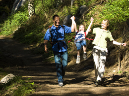


- Suitable for families
Interactive elevation profile
Create PDF
Tour-Details
Starting place: 5273 St. Veit im Innkreis
Destination: 5273 St. Veit im Innkreis
duration: 0h 57m
length: 3,6 km
Altitude difference (uphill): 44m
Altitude difference (downhill): 44m
Lowest point: 407m
Highest point: 446m
difficulty: medium
condition: medium
panoramic view: Individual Views
Paths covering:
Asphalt, Hiking trail
powered by TOURDATA
Route:
municipal center - towards Wimhub - at the Praderbauern farm left up to the high-altitude hiking trail to Fraham - towards Pirat - back to St. Veit im Innkreis
municipal center - towards Wimhub - at the Praderbauern farm left up to the high-altitude hiking trail to Fraham - towards Pirat - back to St. Veit im Innkreis
- Suitable for groups
- Suitable for seniors
- Suitable for single travelers
- Suitable for friends
- Suitable for children
- Spring
- Summer
- Autumn
- Early winter
Please get in touch for more information.
5273 St. Veit im Innkreis
Phone +43 7723 6113
Fax machine +43 7723 6113 - 4
E-Mail gemeinde@st-veit-innkreis.ooe.gv.at
Web www.st-veit-innkreis.at
http://www.st-veit-innkreis.at
Interactive elevation profile
Create PDF
Tour-Details
Starting place: 5273 St. Veit im Innkreis
Destination: 5273 St. Veit im Innkreis
duration: 0h 57m
length: 3,6 km
Altitude difference (uphill): 44m
Altitude difference (downhill): 44m
Lowest point: 407m
Highest point: 446m
difficulty: medium
condition: medium
panoramic view: Individual Views
Paths covering:
Asphalt, Hiking trail
powered by TOURDATA