

Family cross country ski trail Bad Goisern


- Suitable for families
Interactive elevation profile
Create PDF
Tour-Details
Paths covering:
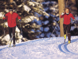
The cross country skiing trail lies entirely in the sun, fascinates with its unique panorama and is suitable for skaters as well as for diagonal skiers.
Sunny cross country skiing trail with unique panorama
The cross country skiing trail was primarily designed for pleasure skiers. It runs largely on flat terrain (just a short climb on the return run) and offers a magnificent view of the valley of Bad Goisern at Lake Hallstatt and the surrounding mountains.
The entry point is right next to the parking lot Predigstuhl.
Here you can find more information about Bad Goisern at Lake Hallstatt and about cross country skiing.
Experience the 360 degree live panorama of Bad Goisern....
Details - Trail
- Nordic skiing facilities: Marked Nordic skiing run
- Type of Nordic skiing run: Classic + skating
- free
December to March, depending on snow conditions
In Bad Goisern take the exit for Lasern at the roundabout and continue along the scenic road in the direction of Predigstuhl until you reach the free parking lot Predigstuhl.
by car
from Salzburg:
Exit Thalgau via federal road B158 towards Bad Ischl, in Bad Ischl drive onto Salzkammergut Street B145 towards Bad Goisern
from Linz:
Exit Regau via federal road Salzkammergut street B145 towards Gmunden and Bad Ischl to Bad Goisern
from Vienna/Graz:
Exit Liezen via federal road B320, in Trautenfels drive onto Salzkammergut street B145 towards Bad Goisern
from Villach:
Tauern motorway to exit "Eben im Pongau", via B166 Pass Gschütt federal road through Gosau, at the Gosaumühle junction turn towards Bad Goisern
by train
Attnang-Puchheim - Stainach-Irdning lines
stop train station Bad Goisern, from there about 6.6 km away
by bus
Bus 542 (Bad Ischl - Gosausee)
stop Bad Goisern Mitte/B145, from there about 5.8 km away
Detailed information on the respective train and bus times can be found at https://www.oebb.at/en/ (train) and https://www.postbus.at/en (bus).
- Parking space: 100
- Bus parking space: 2
for free
The cross country skiing trails in Bad Goisern at Lake Hallstatt are available to you for free.
- Suitable for groups
- Suitable for teenagers
- Suitable for seniors
- Suitable for single travelers
- Suitable for friends
- Suitable for couples
- Suitable for children
- Early winter
- Deep winter
Please get in touch for more information.
")
Kirchengasse 4
4822 Bad Goisern am Hallstättersee
Phone +43 5 95095
Fax machine +43 5 95095 - 74
E-Mail goisern@dachstein-salzkammergut.at
Web www.dachstein-salzkammergut.at
You can also visit us on
Visit us on Facebook Visit us on Instagram Visit us on Pinterest Visit our videochannel on YouTube WikipediaInteractive elevation profile
Create PDF
Tour-Details
Paths covering: