

Rund um Freistadt Nr. 901


- culinary interesting
- culturally interesting
- Flatly
- Possible accommodation
Interactive elevation profile
Create PDF
Tour-Details
Path number: 901
Starting place: 4240 Freistadt
Destination: 4240 Freistadt
duration: 0h 42m
length: 8,9 km
Altitude difference (uphill): 144m
Altitude difference (downhill): 144m
Lowest point: 554m
Highest point: 691m
difficulty: easy
condition: medium
panoramic view: Great panorama
Paths covering:
Asphalt
powered by TOURDATA
Short tour with a climb that is worth it!
Start and finish: Freistadt main square
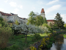
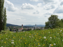
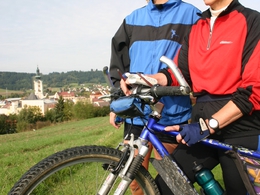
Length: 10 km We start our tour at the main square in Freistadt and cycle through the romantic old town, past the Katharinenmünster and through the Linzertor towards the brewery. The route takes us to the Pregartenteich pond and then onto the so-called Bauernrunde! You should stop at KM 2.5 and enjoy the wonderful panorama of Freistadt. The route continues and now it gets strenuous. We fight our way up to St. Peter where we reach the highest point of the tour. Here you should definitely visit the church of St Peter. Before the descent to Freistadt, it is also worth stopping for refreshments after this effort (GH Brunngraber). Now it's all downhill to Freistadt! We reach the Pregartenteich again (with playground), where it is worth taking a break. In Freistadt we are greeted by the mighty Linzertor gate. In the Eisengasse and on the main square, pavement cafés invite you to round off this tour!
Start and finish: Freistadt main square
Length: 10 km We start our tour at the main square in Freistadt and cycle through the romantic old town, past the Katharinenmünster and through the Linzertor towards the brewery. The route takes us to the Pregartenteich pond and then onto the so-called Bauernrunde! You should stop at KM 2.5 and enjoy the wonderful panorama of Freistadt. The route continues and now it gets strenuous. We fight our way up to St. Peter where we reach the highest point of the tour. Here you should definitely visit the church of St Peter. Before the descent to Freistadt, it is also worth stopping for refreshments after this effort (GH Brunngraber). Now it's all downhill to Freistadt! We reach the Pregartenteich again (with playground), where it is worth taking a break. In Freistadt we are greeted by the mighty Linzertor gate. In the Eisengasse and on the main square, pavement cafés invite you to round off this tour!
Most economical season
- Summer
Please get in touch for more information.
Hauptplatz 1
4240 Freistadt
Phone +43 664 8325756
E-Mail office@freistadt.city
Web freistadt.city
Web www.muehlviertel-urlaub.at/rad
https://freistadt.city
http://www.muehlviertel-urlaub.at/rad
http://www.muehlviertel-urlaub.at/rad
Interactive elevation profile
Create PDF
Tour-Details
Path number: 901
Starting place: 4240 Freistadt
Destination: 4240 Freistadt
duration: 0h 42m
length: 8,9 km
Altitude difference (uphill): 144m
Altitude difference (downhill): 144m
Lowest point: 554m
Highest point: 691m
difficulty: easy
condition: medium
panoramic view: Great panorama
Paths covering:
Asphalt
powered by TOURDATA