

Weißenbach Circular Trail / Number 2


- All weather
- Suitable for families
Interactive elevation profile
Create PDF
Tour-Details
Starting place: 5350 Strobl
Destination: 5350 Strobl
duration: 0h 55m
length: 3,8 km
Altitude difference (uphill): 8m
Altitude difference (downhill): 9m
Lowest point: 547m
Highest point: 562m
difficulty: easy
condition: easy
panoramic view: Some Views
Paths covering:
snow
powered by TOURDATA
Trail not in operation
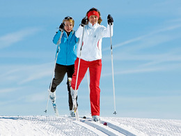
The Weißenbach circular trail is 4 km long, in classique technik and in skating technik. Trail route: The route is southwards from the Alpenmoorbad Hoelt, going under the main road, then on level terrain eastwards to Weißenbach and in an arc back again.Grade: easy, suitable for beginners
In the folder Winter Hiking Trails and Cross Country Skiing you can find the according numbers.
Starting point: Alpenmoorbad Hotel in Strobl
Destination: Alpenmoorbad Hotel in Strobl
Details - Trail
- Nordic skiing facilities: Marked Nordic skiing run
- Type of Nordic skiing run: Classic + skating
December till February

001 Einstieg und Ziel
002 Abzweigung 1 Seeuferloipe
003 Abzweigung 3 Rennloipe Strobl
005 Straßenquerung

006 Höhe Schärferbauer
Accessibility / arrival
Starting points:
Alpenmoorbad Hotel on the south side of Strobl and the Weberhäusl Guesthouse in the village of Weißenbach (P)
- Parking space: 20
General price information
free of charge
- All weather
- Suitable for groups
- Suitable for schools
- Suitable for friends
- Suitable for couples
- Suitable for children
- Early winter
- Deep winter
Please get in touch for more information.
5350 Strobl
Phone +43 6137 7255
Fax machine +43 6137 5958
E-Mail office@wolfgangsee.at
Web www.wolfgangsee.at
http://www.wolfgangsee.at
Interactive elevation profile
Create PDF
Tour-Details
Starting place: 5350 Strobl
Destination: 5350 Strobl
duration: 0h 55m
length: 3,8 km
Altitude difference (uphill): 8m
Altitude difference (downhill): 9m
Lowest point: 547m
Highest point: 562m
difficulty: easy
condition: easy
panoramic view: Some Views
Paths covering:
snow
powered by TOURDATA