

Neumarkter Weg


- Suitable for families
- Flatly
Interactive elevation profile
Create PDF
Tour-Details
Path number: K39
Starting place: 4292 Kefermarkt
Destination: 4292 Kefermarkt
duration: 2h 19m
length: 7,5 km
Altitude difference (uphill): 239m
Altitude difference (downhill): 237m
Lowest point: 465m
Highest point: 685m
difficulty: medium
condition: medium
panoramic view: Some Views
Paths covering:
Hiking trail
powered by TOURDATA
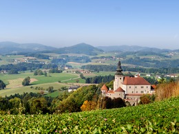
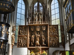
The stately castle high above the village catches the eye from afar as you approach Kefermarkt. Just below it, the parish church harbours a world-famous cultural treasure - the Kefermarkt winged altar.
The Neumarkt hiking trail starts at the town square and leads from there to the outdoor pool following the K39 signs. Continue along the K39 hiking trail over the Lesterbach stream to the Grübl junction. From there, we walk uphill past the Bastl farm and cross the Pernau municipal road to the Piberhofer chapel. The hiking trail continues through the forest past the Thurner and Steininger farmhouses to Neumarkt. The path leads back past the Fehrebesteiner and Aigner farmhouses. There is a rewarding view to Kefermarkt and even as far as the church of St Michael ob Rauchenödt. The route continues downhill back to the starting point.
The Neumarkt hiking trail starts at the town square and leads from there to the outdoor pool following the K39 signs. Continue along the K39 hiking trail over the Lesterbach stream to the Grübl junction. From there, we walk uphill past the Bastl farm and cross the Pernau municipal road to the Piberhofer chapel. The hiking trail continues through the forest past the Thurner and Steininger farmhouses to Neumarkt. The path leads back past the Fehrebesteiner and Aigner farmhouses. There is a rewarding view to Kefermarkt and even as far as the church of St Michael ob Rauchenödt. The route continues downhill back to the starting point.
- Suitable for groups
- Suitable for teenagers
- Suitable for seniors
- Suitable for single travelers
- Suitable for friends
- Suitable for couples
- Spring
- Summer
- Autumn
- Early winter
Please get in touch for more information.
Oberer Markt 15
4292 Kefermarkt
Phone +43 7947 5910
E-Mail gemeinde@kefermarkt.ooe.gv.at
Web www.kefermarkt.ooe.gv.at
Web www.muehlviertel-urlaub.at/wandern
http://www.kefermarkt.ooe.gv.at
http://www.muehlviertel-urlaub.at/wandern
http://www.muehlviertel-urlaub.at/wandern
Interactive elevation profile
Create PDF
Tour-Details
Path number: K39
Starting place: 4292 Kefermarkt
Destination: 4292 Kefermarkt
duration: 2h 19m
length: 7,5 km
Altitude difference (uphill): 239m
Altitude difference (downhill): 237m
Lowest point: 465m
Highest point: 685m
difficulty: medium
condition: medium
panoramic view: Some Views
Paths covering:
Hiking trail
powered by TOURDATA