

Pferdeeisenbahnweg


- pets allowed
- All weather
- Suitable for families
- Suitable for kids (all ages)
- culinary interesting
- culturally interesting
Interactive elevation profile
Create PDF
Tour-Details
Starting place: 4600 Wels
Destination: 4600 Wels
duration: 4h 55m
length: 20,6 km
Altitude difference (uphill): 13m
Altitude difference (downhill): 21m
Highest point: 335m
difficulty: easy
condition: easy
panoramic view: Individual Views
Paths covering:
Asphalt
powered by TOURDATA
Today, a dense rail network surrounds the globe – the means of transport "railway" has long been an integral part of our lives!
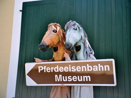
As early as the 19th century, the horse-drawn railway "Budweis-Gmunden" led straight through Wels. Even though the tracks have disappeared today, the buildings where the passenger station used to be or the load station with repair facilities, storage rooms, the lab station, the guard houses and the horse stands have been, are well-preserved. Some of these "horse-drawn railway stations" can be admired along the former horse railway route.
Further information: "Verein Pferdeeisenbahn Wels-Maxlheid", www.bahnzeit.at .
")

")
")

")


")

10, Maxlheid, Maxlhaid, Wels, Oberösterreich, 4600, Austria
12, Maxlheid, Maxlhaid, Wels, Oberösterreich, 4600, Austria
227, Salzburger Straße, Berg, Wels, Oberösterreich, 4600, Austria
29, Zieglerstraße, Pernau, Wels, Oberösterreich, 4600, Austria
51, Europastraße, Brandln, Waidhausen, Wels, Oberösterreich, 4600, Austria
6, Bahnhofstraße, Innere Stadt, Neustadt, Wels, Oberösterreich, 4600, Austria
9, Dragonerstraße, Innere Stadt, Vogelweide, Wels, Oberösterreich, 4600, Austria
9, Maxlheid, Maxlhaid, Wels, Oberösterreich, 4600, Austria
Dr.-Schauer-Straße, Innere Stadt, Neustadt, Wels, Oberösterreich, 4600, Austria
ehemaliger Pferdeeisenbahn-Bahnhof, Stelzhamerstraße, Innere Stadt, Neustadt, Wels, Oberösterreich, 4600, Austria
Felbermayrstraße, Noitzmühle, Hölzl, Wels, Oberösterreich, 4600, Austria
- All weather
- Suitable for groups
- Suitable for schools
- Suitable for kids (all ages)
- Pets allowed
- Suitable for teenagers
- Suitable for seniors
- Suitable for single travelers
- Suitable for friends
- Suitable for couples
- Suitable for children
- Spring
- Summer
- Autumn
- Early winter
- Deep winter
Please get in touch for more information.
Maxlheid 9
4600 Wels
Phone 7242 46716
E-Mail office@bahnzeit.at
Web www.bahnzeit.at/
http://www.bahnzeit.at/
Interactive elevation profile
Create PDF
Tour-Details
Starting place: 4600 Wels
Destination: 4600 Wels
duration: 4h 55m
length: 20,6 km
Altitude difference (uphill): 13m
Altitude difference (downhill): 21m
Highest point: 335m
difficulty: easy
condition: easy
panoramic view: Individual Views
Paths covering:
Asphalt
powered by TOURDATA