

natur.BANK.wege | Großraming | Haingrabeneck | 446301


- Suitable for families
- culturally interesting
Interactive elevation profile
Create PDF
Tour-Details
Starting place: 4463 Großraming
Destination: 4463 Großraming
duration: 1h 0m
length: 2,4 km
Altitude difference (uphill): 290m
Altitude difference (downhill): 6m
Lowest point: 436m
Highest point: 720m
difficulty: easy
condition: easy
panoramic view: Dreamtour
Paths covering:
Asphalt, Path / trail, Street
powered by TOURDATA
Short description:
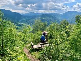
Wonderful view over the Lumplgraben centrally into the Reichraminger Hintergebirge, with its highest elevation, the 1,724 m high Großer Gröstenberg; to the left are the peaks of the Haller Mauern and to the right the long ridge of the Hoher Nock.
Wonderful view over the Lumplgraben centrally into the Reichraminger Hintergebirge, with its highest elevation, the 1,724 m high Großer Gröstenberg; to the left are the peaks of the Haller Mauern and to the right the long ridge of the Hoher Nock.
Quality of experience: *****
Recommended season:
- January
- February
- March
- April
- May
- June
- July
- August
- September
- October
- November
- December
Properties:
- Scenic
- Family friendly
- Cultural/historical value
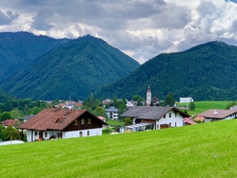
From the centre of the village, a beautiful, leisurely hike, always with wonderful views of Großraming and the southern mountains.
Directions:
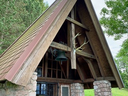
The path leads first on the access road to the Fuchsberger, then from the Hubertus chapel on the perfectly laid out path to the viewing bench
Tip:
Ascent of the 824 m high Haingrabeneck and descent via the Schartenmauer.Beautiful circular hike, with magnificent views to the south of the local mountains of Großraming, the Reichraminger Hintergebirge and to the north from the summit of the Haingrabeneck to the Neustiftgraben and Maria Neustift.
Safety guidelines:
After rainy days, the path in the spruce forest above the Hubertus Chapel is very slippery.
Starting point: Großraming town centre, Salzwimmer car park
Destination: Bench Haingrabeneck
further information:
Accessibility / arrival
Public Transit
By train: the Ennstalbahn runs between Linz and Kleinreifling.
Parking
Großraming Music School, Salzwimmer car park
Getting there
By car from Linz: A1 motorway exit Enns-Steyr > B115 into the Enns Valley
By car from Vienna: A1 motorway exit Amstetten West > Waidhofen / Ybbs > Weyer > Großraming
Public Transit
By train: the Ennstalbahn runs between Linz and Kleinreifling.
Parking
Großraming Music School, Salzwimmer car park
Most economical season
- Spring
- Summer
- Autumn
- Early winter
- Deep winter
Please get in touch for more information.
Stadtplatz 27
4400 Steyr
Phone +43 7252 53229 - 0
E-Mail info@steyr-nationalpark.at
Web www.steyr-nationalpark.at/
https://www.steyr-nationalpark.at/
Interactive elevation profile
Create PDF
Tour-Details
Starting place: 4463 Großraming
Destination: 4463 Großraming
duration: 1h 0m
length: 2,4 km
Altitude difference (uphill): 290m
Altitude difference (downhill): 6m
Lowest point: 436m
Highest point: 720m
difficulty: easy
condition: easy
panoramic view: Dreamtour
Paths covering:
Asphalt, Path / trail, Street
powered by TOURDATA