

101 Leopoldschlag round


Interactive elevation profile
Create PDF
Tour-Details
Path number: 101
Starting place: 4262 Leopoldschlag
Destination: 4262 Leopoldschlag
duration: 3h 0m
length: 36,2 km
Altitude difference (uphill): 737m
Altitude difference (downhill): 734m
Lowest point: 616m
Highest point: 835m
difficulty: medium
condition: medium
panoramic view: Great panorama
Paths covering:
Asphalt, Path / trail, Gravel, Street
powered by TOURDATA
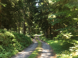
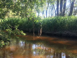
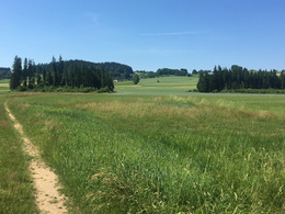
From the start in Leopoldschlag, you cycle along the Maltsch river for the first few kilometres and thus also along the Austrian-Czech border. An ascent begins in Eisenhut, which leads to the Czech Republic. The next five kilometres take you through densely wooded forest areas back to Austria. There is now a long uphill section to Kerschbaum, from where the route continues past the horse-drawn railway museum. After the next ascent, you return to Leopoldschlag via beautiful trails and somewhat more difficult descents. But before you reach the end of this loop, another ten kilometres await, with a steep climb. The last section is only slightly undulating and leads back to the starting point via tarmac and forest paths.
Nature is always there for us. So it is only fair that we are there for nature too.
Fair play rules for mountain biking please be sure to follow them!
Nature is always there for us. So it is only fair that we are there for nature too.
Fair play rules for mountain biking please be sure to follow them!

")
")
")
")
")
")
")
- Suitable for groups
- Suitable for teenagers
- Suitable for single travelers
- Suitable for friends
- Suitable for couples
- Spring
- Summer
- Autumn
Please get in touch for more information.
")
Marktplatz 17
4262 Leopoldschlag
Phone +43 7949 8255
E-Mail gemeinde@leopoldschlag.ooe.gv.at
Web www.muehlviertel-urlaub.at/bike
https://www.muehlviertel-urlaub.at/bike
Interactive elevation profile
Create PDF
Tour-Details
Path number: 101
Starting place: 4262 Leopoldschlag
Destination: 4262 Leopoldschlag
duration: 3h 0m
length: 36,2 km
Altitude difference (uphill): 737m
Altitude difference (downhill): 734m
Lowest point: 616m
Highest point: 835m
difficulty: medium
condition: medium
panoramic view: Great panorama
Paths covering:
Asphalt, Path / trail, Gravel, Street
powered by TOURDATA