

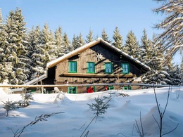
Amstettner Hütte (von Forsteralm) Schneeschuhtour


Interactive elevation profile
Create PDF
Tour-Details
Paths covering:
Short hike from parking 2 of the Forsteralm to the Amstettner Hut
Recommended season:
- January
- February
- March
- November
- December
The trail leads steadily uphill from car park 2 of the Forsteralm to the Amstettner Hütte.
Trail number: E01
Alternative:
Circular trail from Gaflenz via Güterweg and Bürgertal to Amstettner Hütte and via Oberland back to Gaflenz.
Directions:
The trail leads steadily uphill from parking 2 of the Forsteralm to the Amstettner Hütte.
Variant:
Circular trail from Gaflenz via Güterweg and Bürgertal to Amstettner Hütte and via Oberland back to Gaflenz.
Getting there
From Salzburg/Linz: A1 motorway exit Enns-Steyr > B115 into the Enns Valley.
From Vienna: A1 motorway exit Haag > B42 > B122 > B115 into the Enns Valley
From Passau: A8 Passau > Wels > A1 motorway exit Enns-Steyr > B115 into the Enns Valley
From Graz: A9 Pyhrnautobahn > motorway exit Klaus > Grünburg > into the Ennstal valley
Public Transit
he Ennstalbahn runs between Linz and Weißenbach-St. Gallen.
Details at www.ooevv.at
Railway Stations are located in Steyr, Garsten, Lahrndorf, Dürnbach, Ternberg, Trattenbach, Losenstein, Reichraming, Großraming, Gaflenz, Weyer, Küpfern, Kastenreith, Kleinreifling and Weißenbach-St. Gallen.
Parking
Gaflenz/parking 2 of the Forsteralm
- Spring
- Early winter
- Deep winter
Please get in touch for more information.
Stadtplatz 27
4400 Steyr
Phone +43 7252 53229 - 0
E-Mail info@steyr-nationalpark.at
Web www.steyr-nationalpark.at/
Interactive elevation profile
Create PDF
Tour-Details
Paths covering: