

Salzsteigjoch - Tauplitzalm - Tauplitz


Interactive elevation profile
Create PDF
Tour-Details
Path number: 209a, 216
Starting place: 4573 Hinterstoder
Destination: 8982 Bad Mitterndorf
duration: 7h 42m
length: 16,6 km
Altitude difference (uphill): 1.311m
Altitude difference (downhill): 1.094m
Lowest point: 709m
Highest point: 1.732m
difficulty: difficult
condition: difficult
panoramic view: Great panorama
Paths covering:
Climbing mount, Gravel, Hiking trail
powered by TOURDATA
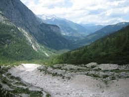
From the parking area of the Bärenalm in Hinterstoder to the Baumschlagerreith (access by car permitted) or via the small bridge onto the left side of the river Steyr and along trail nr. 209a to Baumschlagerreith.
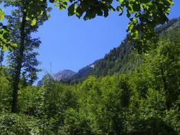
Continue leaving the Steyrursprung to your right, cross a high alpine forest along a gravel path crossing the forest road a few times to the Poppenalm (hunting lodge). Continue on flat terrain to the end of the valley, then steep up to a sparsly grown forest ridge. The path is partly secured with steel ropes, surrounded by romantic rock scenery and leads up over a 100m long gravel fiels to the Salzsteigjoch. A stunning view back over the Stodertal valley is the well earned price for the hardship. To the south of the pass (on the Styrian side) the trail continues softly downhills over pastures and through a sparse larch forest to the Leisteralmhütte.
Now continue either direction Tauplitzalm along trail nr. 216/218, down to the Schwarzensee lake, then above the Steirersee lake and passing several alpine huts until you reach the “Alpine Village Centre“. From here you can either take the chairlift or walk along the toll road to get to the village of Tauplitz. In July, August and September bus transfers are offered from the Tauplitzalm to Hinterstoder!
Trail-Nr: 209a, 216
For hunting reasons, these routes are from 15.9. - 1.10. blocked every year!
Starting point: Parking Baumschlagerreith
Destination: Tauplitzalm
further information:
- Board possible
Accessibility / arrival
From the center of Hinterstoder drive to the parking Baumschlagerreith end of the valley.
Most economical season
- Summer
- Autumn
Please get in touch for more information.

Hinterstoder 38
4573 Hinterstoder
Phone +43 7564 5263 - 99
Fax machine +43 7564 5263 - 30
E-Mail hinterstoder@pyhrn-priel.net
Web www.urlaubsregion-pyhrn-priel.at
http://www.urlaubsregion-pyhrn-priel.at
Interactive elevation profile
Create PDF
Tour-Details
Path number: 209a, 216
Starting place: 4573 Hinterstoder
Destination: 8982 Bad Mitterndorf
duration: 7h 42m
length: 16,6 km
Altitude difference (uphill): 1.311m
Altitude difference (downhill): 1.094m
Lowest point: 709m
Highest point: 1.732m
difficulty: difficult
condition: difficult
panoramic view: Great panorama
Paths covering:
Climbing mount, Gravel, Hiking trail
powered by TOURDATA