

Totes Gebirge from Bad Ischl to Hinterstoder


- Multi-day tour
Interactive elevation profile
Create PDF
Tour-Details
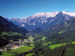
Starting place: 4820 Bad Ischl
Destination: 4574 Hinterstoder
duration: 20h 0m
length: 45,0 km
Altitude difference (uphill): 2.894m
Altitude difference (downhill): 2.902m
Lowest point: 605m
Highest point: 2.052m
difficulty: medium
condition: difficult
panoramic view: Great panorama
Paths covering:
Hiking trail
powered by TOURDATA
roadblock: Rettenbachalm - Blaa-Alm
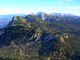
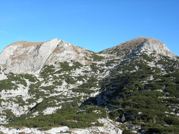
Time period: 01.01.2024 - 31.12.2024 The Dead Mountains are a mountain range in the Northern Limestone Alps in the Eastern Alps in Upper Austria and Styria. This crossing leads through mountain forest of spruce, pine, larch and pine, oversized flower-filled meadows and in the area of high plateau on a heavily karstified and partially devoid of vegetation plateau with fossilized shells, snails and corals, sinkholes and caves.
Numerous variants and mountain climbing are possible. A start is also possible in the Loserhütte on Loser (Altausee). To the east can be done in an extension different versions Zellerhütte or Dümler hut. The excess of the western mountains dead leads in 4-5 days through the south of Upper Austria and Styria north of Bad Ischl to Hinterstoder.
Day 1: Arrival to Rettenbachtal and climb to the hut Ischl
Day 2: About the Schoenberg / Wildkogel to Wildensee and Appelhaus
Day 3: Passing the Wildgössl to Pühringerhütte with Elmsee
Day 4: About the Temelbergsattel to Prielschutzhaus
Day 5: down into the valley to Hinterstoder and home
Accessibility / arrival
The tour starts at the Rettenbachalm in Bad Ischl.
Most economical season
- Summer
Please get in touch for more information.
4820 Bad Ischl
Phone +43 7564 5263
E-Mail hinterstoder@pyhrn-priel.net
Web www.urlaubsregion-pyhrn-priel.at/hi…
https://www.urlaubsregion-pyhrn-priel.at/hinterstoder-1.html
Interactive elevation profile
Create PDF
Tour-Details
Starting place: 4820 Bad Ischl
Destination: 4574 Hinterstoder
duration: 20h 0m
length: 45,0 km
Altitude difference (uphill): 2.894m
Altitude difference (downhill): 2.902m
Lowest point: 605m
Highest point: 2.052m
difficulty: medium
condition: difficult
panoramic view: Great panorama
Paths covering:
Hiking trail
powered by TOURDATA