

Almtal trail Viechtwang


Interactive elevation profile
Create PDF
Tour-Details
Starting place: 4644 Scharnstein
Destination: 4644 Scharnstein
duration: 0h 58m
length: 4,0 km
Altitude difference (uphill): 8m
Altitude difference (downhill): 11m
Lowest point: 516m
Highest point: 529m
difficulty: medium
condition: very easy
panoramic view: No view
Paths covering:
snow
powered by TOURDATA
Trail not in operation
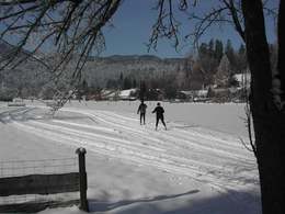
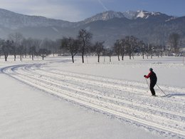
Cross-country skiing in the Almtal - drive through the beautiful winter landscape on cross-country skis.
In the attractive network of trails with trails of various lengths and levels of difficulty, both beginners and cross-country skiing pros will find the right track here.
Viechtwang trail: From the Fliegerbar car park, the trail leads you across the Seewiese in the direction of the main road, which you then have to cross. You now drive in a nice round to the riding hall and back to the main road and on to the starting point.
We ask you to stick to the running direction and keep the trail clean. Please note the "No Dogs" signs. Help us maintain and maintain the trail with a donation. You can donate to the savings boxes that are set up and thus become a "sponsor of the Almtal cross-country ski trail".
Parking
- Parking space: 40
Payment methods
Other payment methods
Cash payment
Most economical season
- Deep winter
Please get in touch for more information.

Im Dorf 17
4645 Grünau im Almtal
Phone +43 7616 8268
E-Mail almtal@traunsee-almtal.at
Web traunsee-almtal.salzkammergut.at/
https://traunsee-almtal.salzkammergut.at/
You can also visit us on
Visit us on FacebookInteractive elevation profile
Create PDF
Tour-Details
Starting place: 4644 Scharnstein
Destination: 4644 Scharnstein
duration: 0h 58m
length: 4,0 km
Altitude difference (uphill): 8m
Altitude difference (downhill): 11m
Lowest point: 516m
Highest point: 529m
difficulty: medium
condition: very easy
panoramic view: No view
Paths covering:
snow
powered by TOURDATA