

Hausloipe


- Suitable for families
- culinary interesting
- Flatly
- Possible accommodation
Interactive elevation profile
Create PDF
Tour-Details
Starting place: 4264 Grünbach
Destination: 4264 Grünbach
duration: 0h 45m
length: 4,0 km
Altitude difference (uphill): 64m
Altitude difference (downhill): 64m
Lowest point: 848m
Highest point: 898m
difficulty: easy
condition: easy
panoramic view: Some Views
Paths covering:
snow
powered by TOURDATA
Trail not in operation
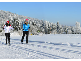
The perfectly groomed cross-country ski trails in the Freistadt region lie in the middle of a snow-covered, peaceful winter landscape with meadow slopes and lead past small, romantic streams.
At the Forellenwirt Kastler, you can warm up and fortify yourself after your sporting activity on the surrounding trails.
Hausloipe: easy circuit - particularly suitable for beginners and families with children. Leads along the forest from the start and thus offers a nice introduction.
House trail is 4 km long - family trail, classic, double tracked and easy
Information on the current trail situation can be found here: +43 (0)7942/72804
Starting point: Mitterbach 6 (Forellenwirt Kastler)
Destination: Mitterbach 6 (Forellenwirt Kastler)
further information:
- culinary interesting
- Flatly
- Possible accommodation
- Board possible
Details - Trail
- Nordic skiing facilities: Marked Nordic skiing run
- Type of Nordic skiing run: Classic + skating
- free
Accessibility / arrival
by car:
A1 to Linz - A7 to Unterweitersdorf, S10 to exit Sandl/Grünbach - roundabout 1st exit (direction Sandl) - B 38 to Schlag (approx. 500 m) - turn left to Grünbach.
by train:
Summerauerbahn to Freistadt or Summerau, 7 km to Grünbach
- Parking space: 85
General price information
Contribution towards expenses: voluntary donations
- Suitable for groups
- Suitable for schools
- Suitable for teenagers
- Suitable for seniors
- Suitable for single travelers
- Suitable for families
- Suitable for friends
- Suitable for couples
- Suitable for children
- Deep winter
Please get in touch for more information.
")
Marktplatz 1
4264 Grünbach
Phone +43 7942 72813
E-Mail gemeinde@gruenbach.ooe.gv.at
Web www.gruenbach.ooe.gv.at/
http://www.gruenbach.ooe.gv.at/
Interactive elevation profile
Create PDF
Tour-Details
Starting place: 4264 Grünbach
Destination: 4264 Grünbach
duration: 0h 45m
length: 4,0 km
Altitude difference (uphill): 64m
Altitude difference (downhill): 64m
Lowest point: 848m
Highest point: 898m
difficulty: easy
condition: easy
panoramic view: Some Views
Paths covering:
snow
powered by TOURDATA