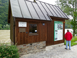
Pegelhäuschen an der Donau
Engelhartszell, Oberösterreich, Österreich
Life with the water levels
The knowledge about the water level of the Danube is crucial to shipping. It also influences the life of the local population, especially during times of flooding. That’s why we see along the Danube hiking trail regularly tide gauges where you can read directly the water level, but also several types of water level stations in which the water level is documented.
Now the question arises: “How is the water level of the Danube measured?”
The water level is always measured in relation to a zero point of gauge (gauge datum). However, this point lies not at the river bank of the Danube but a little bit beneath the local and over a long period documented lowest water level. Important: The gauge datum needs to be chosen in such a way that negative water levels are not possible. Consequently, the water is always deeper in reality than the stated water level. So be careful- when newspapers report a water level of 70 m this doesn’t mean you can wade through the Danube!
4090 Engelhartszell
Phone +43 7717 8055
Fax machine +43 7717 8055 - 22
E-Mail gemeinde@engelhartszell.ooe.gv.at
Web www.engelhartszell.at
http://www.engelhartszell.at
Contact person
Marktgemeinde Engelhartszell
Marktplatz 61
4090 Engelhartszell
Phone +43 7717 8055
Fax machine +43 7717 8055 - 22
E-Mail gemeinde@engelhartszell.ooe.gv.at
Web www.engelhartszell.at
- always open (24/7)
Season
- Spring
- Summer
- Autumn
- Winter
Please get in touch for more information.
powered by TOURDATA


