Hongar - Hongaralm
Starting place: 4861 Aurach am Hongar
Destination: 4861 Aurach am Hongar
Kasten 32
4861 Aurach am Hongar
4861 Aurach am Hongar

Pram - Wanderweg
We start this short hike at the Hongar car park and follow either the goods road suitable for pushchairs or the marked hiking trail up to the Almgasthaus Schwarz. There is a new adventure playground with a cable car, trampoline, children's tent and a barbecue area. There is also a game and dwarf goat enclosure for the little ones. From the Almgasthaus Schwarz we hike on to the Hongar summit and reach the beautiful Hongaralm with cattle. We are also rewarded with a marvellous panoramic view. After a rest, we take the same route back to the starting point.Refreshment stop:
Gasthaus Schwarz, Hongar - Tel. 07662 2012
Starting place: 4861 Aurach am Hongar
Destination: 4861 Aurach am Hongar
duration: 1h 3m
length: 2,0 km
Altitude difference (uphill): 237m
Altitude difference (downhill): 15m
Lowest point: 712m
Highest point: 934m
difficulty: easy
condition: easy
panoramic view: Some Views
Paths covering:
Hiking trail
further information:
- Board possible
Details - hiking
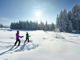
- cleared winter hiking path
- Suitable for kids (all ages)
- Spring
- Summer
- Autumn
Please get in touch for more information.
Kasten 32
4861 Aurach am Hongar
Phone +43 7662 2012
E-Mail h.schwarz@web6262.at
Web www.aurach.at
http://www.aurach.at


