

Klam: Klam Loop Trail


- Flatly
Interactive elevation profile
Create PDF
Tour-Details
Starting place: 4352 Klam
Destination: 4352 Klam
duration: 2h 0m
length: 6,0 km
Altitude difference (uphill): 103m
Altitude difference (downhill): 103m
Lowest point: 279m
Highest point: 382m
difficulty: easy
condition: very easy
panoramic view: Some Views
Paths covering:
Asphalt, Gravel, Other
powered by TOURDATA
Short description:
Loop hike through forests and across meadows.
Loop hike through forests and across meadows.
Recommended season:
- April
- May
- June
- July
- August
- September
- October
Properties:
Description:- Loop
- Refreshment stops available
We start at the municipal office in Klam, No. 43, 4352 Klam and hike north-eastwards. After some 300m we take a left turn and walk along side roads to Linden. We keep the direction until the road takes a left turn after the last farm house. We take a left turn into the forest at the next crossing and after some 1.5km we pass a farm house and continue on the road southwards. At the next crossing we meet Donausteig Trail and follow it back to Klam.Directions:
Wir starten beim Gemeindeamt in Klam und wandern nach Nordosten. Nach ca. 300 m biegen wir links ab und gehen auf Nebenstraßen nach Linden. Wir behalten die Richtung bei bis sich die Straße nach dem letzten Bauernhof nach links wendet. Bei der nächsten Kreuzung biegen wir links in den Wald hinein ab. Nach ca. 1,5 km kommen wir bei einem Bauernhaus vorbei und gehen auf der Straße weiter nach Süden. Bei der nächsten Kreuzung treffen wir auf den Donausteig und folgen diesem zurück nach Klam.Tip:
Diese Tour wird Ihnen präsentiert von der Tourismusregion Donau OberösterreichEquipment:
Wanderrucksack (inkl. Regenhülle), festes SchuhwerkAdditional information:
Klam Municipal Office
4352 Klam 43
Tel.: 0043(0)7269/7255
Fax: 0043(0)7269/7255-4
E-mail: gemeinde@klam.at
www.klam.at
Starting point: Klam
Destination: Gemeindeamt Klam
further information:
- Flatly
- Board possible

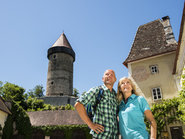
Panoramablick Burg Clam

Rastplatz Mühlberg
Startplatz Klam

Startplatz Klam
Rastplatz Mühlberg
")
Panoramablick Burg Clam
Accessibility / arrival
www.postbus.atParking
Public car park opposite of the municipal office
Getting there
Coming from Linz: on the B3 to Baumgartenberg, take then a left turn towards Klam.
Coming from Vienna: on the A1 autobahn to Ybbs, continue on the B3 to Grein, take a right turn towards Klam
Public Transitwww.postbus.atParking
Public car park opposite of the municipal office
Most economical season
- Spring
- Summer
- Autumn
Please get in touch for more information.
Klam 43
4352 Klam
Phone +43 43 7255
Fax machine +43 7269 72554
E-Mail gemeinde@klam.at
Web www.klam.at
Web www.donauregion.at
https://www.klam.at
http://www.donauregion.at
http://www.donauregion.at
Interactive elevation profile
Create PDF
Tour-Details
Starting place: 4352 Klam
Destination: 4352 Klam
duration: 2h 0m
length: 6,0 km
Altitude difference (uphill): 103m
Altitude difference (downhill): 103m
Lowest point: 279m
Highest point: 382m
difficulty: easy
condition: very easy
panoramic view: Some Views
Paths covering:
Asphalt, Gravel, Other
powered by TOURDATA