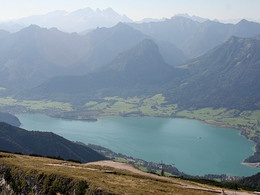
Schafberg (via Winkl)
Starting place: 5360 St. Gilgen
Destination: 5360 St. Gilgen
Start: Church square St. Gilgen
On the Mondseestraße road to the hamlet of Winkl (approx. 1/2 h) or drive up to the carpark in Winkl on the main road B 154. From here follow trail No. 20 to the Schafbergalm pastures and up to the top of the Schafberg montain.
On the Mondseestraße road to the hamlet of Winkl (approx. 1/2 h) or drive up to the carpark in Winkl on the main road B 154. From here follow trail No. 20 to the Schafbergalm pastures and up to the top of the Schafberg montain.
Starting place: 5360 St. Gilgen
Destination: 5360 St. Gilgen
duration: 4h 25m
length: 9,8 km
Altitude difference (uphill): 798m
Altitude difference (downhill): 489m
Lowest point: 492m
Highest point: 868m
difficulty: medium
condition: medium
panoramic view: Great panorama
Paths covering:
Asphalt, Gravel, Hiking trail
Starting point: Church square St. Gilgen
Destination: summit of the Schafberg
- Suitable for single travelers
- Suitable for friends
- Suitable for couples
- Spring
- Summer
- Autumn
Please get in touch for more information.
Au 140
5360 St. Wolfgang im Salzkammergut
Phone +43 6138 8003
E-Mail info@wolfgangsee.at
Web wolfgangsee.salzkammergut.at
https://wolfgangsee.salzkammergut.at


