Naturparkweg
Starting place: 4324 Rechberg
Destination: 4324 Rechberg
Rechberg 9
4324 Rechberg
4324 Rechberg

Qualified hiking trail
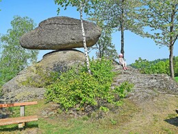
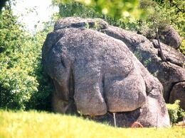
One of the most beautiful hikes in the Mühlviertel is certainly the nature park trail in Rechberg.On the way from the village square to the "Schwammerling", Rechberg's landmark, you will find the Hinterwinkler family's organic farm shop, past the forest workshop, the fox walls and on to the "Pammer Höhe" to the Elefantenstein.
Nikola Jakadofsky's ceramics studio is located directly on the way to the Großdöllnerhof open-air museum. The farmstead, which is over 400 years old, stands beautifully on a hill with a marvellous view of the Mühlviertel. Take your time and enjoy the moment!
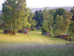
The trail leads to the stone nature trail, across the stone meadow to the Karl Weichselbaumer lookout point, one of the most marvellous vantage points with views from the Ötscher to the Traunstein. Pass the pre-Christian cult site and descend the Plenkerberg to the starting point at the village square.
Accessibility / arrival
Highway exit Enns - over the Danube bridge in the direction of Mauthausen - on the main road (B3) to Perg - via Windhaag to Rechberg
Linz main station via St. Valentin --> Perg station --> by car/bus approx. 12 km to Rechberg
- All weather
- Suitable for groups
- Suitable for schools
- Suitable for kids (all ages)
- Suitable for teenagers
- Suitable for seniors
- Suitable for single travelers
- Suitable for families
- Suitable for friends
- Suitable for couples
- Suitable for children
- Spring
- Summer
- Autumn
Please get in touch for more information.
Rechberg 9
4324 Rechberg
Phone +43 7264 4655
E-Mail gemeindeamt@rechberg.ooe.gv.at
Web www.rechberg.at/
Web www.naturpark-muehlviertel.at
https://www.rechberg.at/
http://www.naturpark-muehlviertel.at
http://www.naturpark-muehlviertel.at


