

Kellergröppenweg


- Suitable for families
- Flatly
Interactive elevation profile
Create PDF
Tour-Details
Starting place: 4760 Raab
Destination: 4760 Raab
duration: 0h 48m
length: 2,9 km
Altitude difference (uphill): 45m
Altitude difference (downhill): 45m
Lowest point: 372m
Highest point: 398m
difficulty: very easy
condition: very easy
panoramic view: Individual Views
Paths covering:
Asphalt, Hiking trail
powered by TOURDATA
Description:
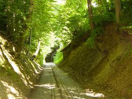
Starting from the school centre, the trail leads to Moarhof, from there a short distance next to the Bründlbach and through the Kellergröppe to Bründlallee.
Follow the avenue northwards to the Maria Bründl pilgrimage church, down the Ameisleiten and along the Bründlbach stream back to the starting point.
The Kellergröppe, a medieval hollow way with 26 sand cellars, is unique in Upper Austria. The cellars with a constant temperature of eight degrees were once mainly used for storing beer.
- Suitable for groups
- Suitable for schools
- Suitable for teenagers
- Suitable for seniors
- Suitable for single travelers
- Suitable for families
- Suitable for friends
- Suitable for couples
- Spring
- Summer
- Autumn
- Early winter
- Deep winter
Please get in touch for more information.
Marktstraße 7
4760 Raab
Phone +43 7762 2255
E-Mail gemeinde@raab.ooe.gv.at
Web www.raab.ooe.gv.at/system/web/sonde…
http://www.raab.ooe.gv.at/system/web/sonderseite.aspx?menuonr=219567021&detailonr=219567021
Interactive elevation profile
Create PDF
Tour-Details
Starting place: 4760 Raab
Destination: 4760 Raab
duration: 0h 48m
length: 2,9 km
Altitude difference (uphill): 45m
Altitude difference (downhill): 45m
Lowest point: 372m
Highest point: 398m
difficulty: very easy
condition: very easy
panoramic view: Individual Views
Paths covering:
Asphalt, Hiking trail
powered by TOURDATA