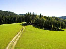
Fitnessweg "Sagenhaftes Witrauntal"
Starting place: 4761 Enzenkirchen
Destination: 4761 Enzenkirchen
Immerse yourself in a fabulous world
The "Legendary Witraun Valley" hiking and fitness trail takes you into a fairytale world. On lush green meadows, in dark deciduous and coniferous forests and along refreshing waters, you can immerse yourself in the wealth of legends and the past of the Witraun Valley.
Route route:
Enzenkirchen - Bimmersdorf - Hacking - Mühlwitraun - Oberheitzing - Goldberg - Ruprechtsberg - Hintersberg - Enzenkirchen
Description:
The "Legendary Witrauntal" hiking trail is 8 kilometres long. The trail starts in Enzenkirchen, leads via Bimmersdorf to Hacking, on to Mühlwitraun and Oberheitzing to Goldberg. It continues to Ruprechtsberg and Hintersberg and back to Enzenkirchen. The short loop is 5.4 kilometres long and leads back to Enzenkirchen before the village of Goldberg.
Most economical season
- Spring
- Summer
- Autumn
Please get in touch for more information.
Phone +43 7762 3215
E-Mail gemeinde@enzenkirchen.ooe.gv.at
Web www.enzenkirchen.ooe.gv.at
http://www.enzenkirchen.ooe.gv.at


