R4 Haula - Runde (Mountainbike)
Starting place: 4770 Andorf
Destination: 4770 Andorf
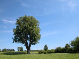
This moderately difficult cycle tour runs via Lichtegg to the Innviertel herb garden, on to the municipality of Raab to Hörzberg, past the "Kaiserlinde" viewpoint - which was planted on the Kirchenberg on the occasion of Emperor Franz Joseph's 68th birthday in 1898 - and on to Andorf.
The lime tree was unfortunately destroyed by several arson attacks, but in 2011 the four Andorf fire brigades replanted a new lime tree at the same location.
Total length: 17 km
Signposting: R4
The lime tree was unfortunately destroyed by several arson attacks, but in 2011 the four Andorf fire brigades replanted a new lime tree at the same location.
Total length: 17 km
Signposting: R4
Most economical season
- Spring
- Summer
- Autumn
Please get in touch for more information.
Hauptstraße 32
4770 Andorf
Phone +43 7766 2255 - 15
E-Mail tourismus@andorf.ooe.gv.at
Web www.tourismus-andorf.at
http://www.tourismus-andorf.at


