Innviertel Bike Path R22
Path number: R22
Starting place: 4770 Andorf
Destination: 4922 Hohenzell
Hauptstraße 32
4770 Andorf
4770 Andorf

It is best to start your tour at the info point of the Tourism Association in Andorf (Tourismusverband). (VVA premises, Sportplatzstrasse)
Path number: R22
Starting place: 4770 Andorf
Destination: 4922 Hohenzell
duration: 2h 26m
length: 32,6 km
Altitude difference (uphill): 405m
Altitude difference (downhill): 275m
Lowest point: 344m
Highest point: 530m
difficulty: difficult
condition: medium
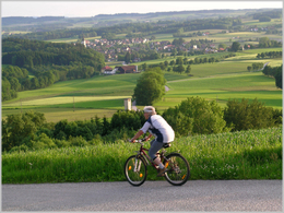
panoramic view: Great panorama
Paths covering:
Asphalt, Gravel
Starting point: In the centre of Andorf or at the info point of the tourism association (Tourismusverband) in Sportplatzstrasse.
further information:
- Board possible
Accessibility / arrival
By car:
Travelling from Germany on the A8 - exit Pocking - further on the B 12 towards Schärding-Linz - then further on the B 137 towards Linz (approx. 12 km to Andorf) - exit Andorf (Note: take the motorway exit Suben > road tax disc necessary !!)
Arrival from Wels, Linz ... via the B 137 - exit Andorf
Arrival from Salzburg, Ried/I.: L 514
By rail:
Arrival via the stretch Passau - Wels, Andorf railway station
- Parking space: 100
- Bus parking space: 5
- All weather
- Spring
- Summer
- Autumn
Please get in touch for more information.
Hauptstraße 32
4770 Andorf
Phone +43 7766 2255 - 15
E-Mail tourismus@andorf.ooe.gv.at
Web www.andorf.at
http://www.andorf.at


