

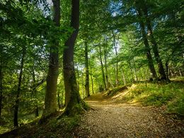
Teufeltalwanderung 133


Interactive elevation profile
Create PDF
Tour-Details
Starting place: 5230 Munderfing
Destination: 5230 Munderfing
duration: 2h 59m
length: 11,1 km
Altitude difference (uphill): 150m
Altitude difference (downhill): 146m
Lowest point: 470m
Highest point: 602m
difficulty: medium
condition: medium
panoramic view: Some Views
Paths covering:
Hiking trail, Other
powered by TOURDATA
Munderfing-Bradirn-at the plant hut turn right into Teufeltal-via Schmaierl into Katztal - Mundelrfing
approx. 8 km
approx. 8 km
Most economical season
- Spring
- Summer
- Autumn
Please get in touch for more information.
Stadtplatz 2
5280 Braunau am Inn
Phone +43 7722 62644
E-Mail gemeinde@munderfing.ooe.gv.at
Web www.munderfing.at
http://www.munderfing.at
Interactive elevation profile
Create PDF
Tour-Details
Starting place: 5230 Munderfing
Destination: 5230 Munderfing
duration: 2h 59m
length: 11,1 km
Altitude difference (uphill): 150m
Altitude difference (downhill): 146m
Lowest point: 470m
Highest point: 602m
difficulty: medium
condition: medium
panoramic view: Some Views
Paths covering:
Hiking trail, Other
powered by TOURDATA