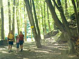
Schilchersteig


- pets allowed
- All weather
- Suitable for families
- Suitable for kids (all ages)
Interactive elevation profile
Create PDF
Tour-Details
Starting place: 4785 Freinberg
Destination: 4785 Schardenberg
duration: 2h 9m
length: 7,2 km
Altitude difference (uphill): 259m
Altitude difference (downhill): 38m
Lowest point: 309m
Highest point: 535m
difficulty: easy
condition: easy
panoramic view: Some Views
Paths covering:
Hiking trail
powered by TOURDATA
Along the romantic stream in the shady deciduous forest. The forest path is also part of the Via Nova pilgrimage route
- All weather
- Suitable for groups
- Suitable for schools
- Suitable for kids (all ages)
- Pets allowed
- Suitable for teenagers
- Suitable for seniors
- Suitable for single travelers
- Suitable for families
- Suitable for friends
- Suitable for couples
- Suitable for children
- Spring
- Summer
- Autumn
Please get in touch for more information.
4785 Freinberg
Phone +43 7713 8102
E-Mail gemeinde@freinberg.at
Web www.freinberg.at
http://www.freinberg.at
Interactive elevation profile
Create PDF
Tour-Details
Starting place: 4785 Freinberg
Destination: 4785 Schardenberg
duration: 2h 9m
length: 7,2 km
Altitude difference (uphill): 259m
Altitude difference (downhill): 38m
Lowest point: 309m
Highest point: 535m
difficulty: easy
condition: easy
panoramic view: Some Views
Paths covering:
Hiking trail
powered by TOURDATA