Zur Mostschänke Oberndorf

 Interactive elevation profile

Download GPS data
Create PDF

Tour-Details

Starting place: 4720 Neumarkt im Hausruckkreis
Destination: 4720 Neumarkt im Hausruckkreis

duration: 2h 56m
length: 11,2 km
Altitude difference (uphill): 122m
Altitude difference (downhill): 118m

Lowest point: 381m
Highest point: 445m

powered by TOURDATA

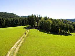
Starting point: Neumarkt-Kallham railway station. From the station, the hike leads through the market town of Neumarkt and then to the neighbouring municipality of Kallham and then northwards through flat farmland and through the Hochholz to Oberndorf to the Mostschänke. You return to Neumarkt via Holzhäuseln on a country road with only moderate traffic.
Travelling by public transport
Route planner for independent travellers
Most economical season
  • Spring
  • Summer
  • Autumn

Please get in touch for more information.


Zur Mostschänke Oberndorf
Bahnhofstraße
4720 Neumarkt im Hausruckkreis

Phone +43 7733 7254
E-Mail gemeinde@neumarkt-hausruck.ooe.gv.at
Web www.neumarkt-hausruckkreis.at
http://www.neumarkt-hausruckkreis.at

We speak the following languages

German

 Interactive elevation profile

Download GPS data
Create PDF

Tour-Details

Starting place: 4720 Neumarkt im Hausruckkreis
Destination: 4720 Neumarkt im Hausruckkreis

duration: 2h 56m
length: 11,2 km
Altitude difference (uphill): 122m
Altitude difference (downhill): 118m

Lowest point: 381m
Highest point: 445m

powered by TOURDATA