

Gangsteig Weg Nr. 140


Interactive elevation profile
Create PDF
Tour-Details
Starting place: 5222 Munderfing
Destination: 5222 Munderfing
duration: 1h 5m
length: 4,4 km
Altitude difference (uphill): 19m
Lowest point: 467m
Highest point: 490m
difficulty: easy
condition: easy
panoramic view: Individual Views
Paths covering:
Asphalt, Gravel, Street, Hiking trail, Other
powered by TOURDATA
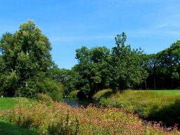
Beautiful riverside path no. 140 along the Schwemmbach to the village of Kolming (Wirt'z Kolming inn) family Eidenhammer with beautiful garden, continue to Aug (Teichstätt wetland biotope) approx. 5 km
Most economical season
- Spring
- Summer
- Autumn
Please get in touch for more information.
Stadtplatz 2
5280 Braunau am Inn
Phone +43 7722 62644
E-Mail info@entdeckerviertel.at
Web www.entdekcerviertel.at
Web munderfing.at
http://www.entdekcerviertel.at
http://munderfing.at
http://munderfing.at
Interactive elevation profile
Create PDF
Tour-Details
Starting place: 5222 Munderfing
Destination: 5222 Munderfing
duration: 1h 5m
length: 4,4 km
Altitude difference (uphill): 19m
Lowest point: 467m
Highest point: 490m
difficulty: easy
condition: easy
panoramic view: Individual Views
Paths covering:
Asphalt, Gravel, Street, Hiking trail, Other
powered by TOURDATA