Eggelsberger Waldweg
Starting place: 5142 Eggelsberg
Destination: 5142 Eggelsberg

From Eggelsberg we walk or drive about half a kilometre on the road leading to Mattighofen to the entrance to the forest. There is a small car park for cars.
The start of the forest path is clearly signposted.
Hikers are advised to visit the nearby Teufelweiher pond after about 50 steps to the left on a track. This small pond, surrounded by forest, was formed after the last ice age and is a geological feature. Locals can also tell of strange incidents in ancient times.
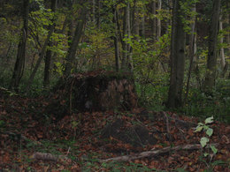
The hiking trail now leads us through a young forest near the edge of the forest and then climbs quite steeply through the high forest. The path bends just before reaching the hill.
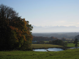
We now make a short detour to the edge of the forest. Here we have a wonderful view of the hilly foothills of the Alps and can admire the mountain panorama from the Dachstein to the Zugspitze on a clear day.
A display board explains how our landscape was formed. Here we are at one of the most beautiful and interesting viewing points in the region and a bench invites you to linger. Back to the marked path - this now leads into a forest path that takes us to the long ridge (moraine hill). We follow the markings and walk through a largely unspoilt copper beech forest with some beautiful views of the rural cultural landscape and return to the starting point of our hike.
Most economical season
- Spring
- Summer
- Autumn
- Early winter
Please get in touch for more information.
5142 Eggelsberg
Phone +43 7748 2255
mobile +43 664 5604123
E-Mail ausflug@aon.at
Web www.moor-ausflug.at
http://www.moor-ausflug.at


