© Foto: Oberösterreich Tourismus GmbH/Robert Maybach: Gesellige Runde am Wolfgangsee
Gruppe junger Menschen auf einem Steg am Wolfgangsee

Schlossrunde

 Interactive elevation profile

Download GPS data
Create PDF

Tour-Details

Starting place: 4771 Sigharting
Destination: 4771 Sigharting

duration: 0h 44m
length: 2,7 km
Altitude difference (uphill): 38m
Altitude difference (downhill): 32m

Lowest point: 338m
Highest point: 380m
difficulty: easy
condition: easy
panoramic view: Individual Views

powered by TOURDATA

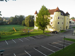
This hiking trail leads you into the fields of the municipality (length approx. 2.8 km).
Travelling by public transport
Route planner for independent travellers
Most economical season
  • Spring
  • Summer
  • Autumn

Please get in touch for more information.


Schlossrunde
Hofmark 5
4771 Sigharting

Phone +43 7766 2405 - 0
Fax machine +43 7766 2405 - 15
E-Mail gemeinde@sigharting.ooe.gv.at
Web www.sigharting.at
http://www.sigharting.at

We speak the following languages

German

 Interactive elevation profile

Download GPS data
Create PDF

Tour-Details

Starting place: 4771 Sigharting
Destination: 4771 Sigharting

duration: 0h 44m
length: 2,7 km
Altitude difference (uphill): 38m
Altitude difference (downhill): 32m

Lowest point: 338m
Highest point: 380m
difficulty: easy
condition: easy
panoramic view: Individual Views

powered by TOURDATA