

Rödhamerhöhe - Rundwanderweg 1
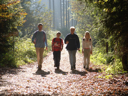


- Suitable for families
Interactive elevation profile
Create PDF
Tour-Details
Starting place: 5273 Roßbach
Destination: 5273 Roßbach
duration: 1h 51m
length: 6,5 km
Altitude difference (uphill): 131m
Altitude difference (downhill): 131m
Lowest point: 429m
Highest point: 533m
difficulty: medium
condition: medium
panoramic view: Individual Views
Paths covering:
Asphalt, Hiking trail
powered by TOURDATA
Route:
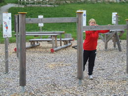
Roßbach town square - past the playground to the old vicarage and on to the "Pfarrermann" (the oldest house in Roßbach including the Bodingbauer chapel) - after crossing the Aspacher road - along the Via Nova path - past the Badegruber (good vantage point, view of Eberschwang wind turbines) - continue to the homecoming chapel (Marienkapelle) - through the forest in the direction of Schwathof - via Buch back to the starting point
Roßbach town square - past the playground to the old vicarage and on to the "Pfarrermann" (the oldest house in Roßbach including the Bodingbauer chapel) - after crossing the Aspacher road - along the Via Nova path - past the Badegruber (good vantage point, view of Eberschwang wind turbines) - continue to the homecoming chapel (Marienkapelle) - through the forest in the direction of Schwathof - via Buch back to the starting point
- Suitable for groups
- Suitable for teenagers
- Suitable for friends
- Suitable for couples
- Spring
- Summer
- Autumn
- Early winter
Please get in touch for more information.
5273 Roßbach
Phone +43 7724 8110
Fax machine +43 7724 8110 - 14
E-Mail gemeinde@rossbach.ooe.gv.at
Web www.rossbach.at
http://www.rossbach.at
Interactive elevation profile
Create PDF
Tour-Details
Starting place: 5273 Roßbach
Destination: 5273 Roßbach
duration: 1h 51m
length: 6,5 km
Altitude difference (uphill): 131m
Altitude difference (downhill): 131m
Lowest point: 429m
Highest point: 533m
difficulty: medium
condition: medium
panoramic view: Individual Views
Paths covering:
Asphalt, Hiking trail
powered by TOURDATA