

Geretsberger Friedenspanoramaweg (Tour/Wanderung)


Interactive elevation profile
Create PDF
Tour-Details
Starting place: 5132 Geretsberg
Destination: 5132 Geretsberg
duration: 2h 12m
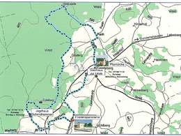
length: 8,5 km
Altitude difference (uphill): 78m
Altitude difference (downhill): 77m
Lowest point: 469m
Highest point: 514m
difficulty: easy
condition: easy
panoramic view: No view
Paths covering:
Asphalt
powered by TOURDATA
The hike begins at Geretsberg church square and leads into the Weilhartsforst forest to the legendary Viperkapelle chapel. The route continues along forest paths to Werberg and from there to the chapel at Geretsberg's Friedenspanoramaplatz. It invites you to pause for a moment before returning to the starting point. Refreshment stops enrich the hiking trail
Most economical season
- Spring
- Summer
- Autumn
Please get in touch for more information.
mobile +43 664 3946369
E-Mail urlaub@seelentium.at
Web www.geretsberg.at
Web www.seelentium.at
http://www.geretsberg.at
http://www.seelentium.at
http://www.seelentium.at
Interactive elevation profile
Create PDF
Tour-Details
Starting place: 5132 Geretsberg
Destination: 5132 Geretsberg
duration: 2h 12m
length: 8,5 km
Altitude difference (uphill): 78m
Altitude difference (downhill): 77m
Lowest point: 469m
Highest point: 514m
difficulty: easy
condition: easy
panoramic view: No view
Paths covering:
Asphalt
powered by TOURDATA