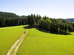
Steinbach Meditationsweg
Starting place: 4294 St. Oswald bei Freistadt
Destination: 4294 St. Oswald bei Freistadt
Steinbach meditation path
Themed trail: Cross-border project - Meditation trail St. Oswald near Freistadt and Abtweg in Vyssi Brod/CZ Signposting in 2 languages D/CZBoth hiking trails have a historical, religious background. The 2 hiking trails are dedicated to the themes of contemplation, active experience in unspoilt nature and meditation.
A meditative programme awaits you along the Steinbach stream in beautiful natural surroundings.
At the end point of the hiking trail, the Maria Bründl pilgrimage church, there is a radon-containing healing spring in the chapel, as well as a public healing water chapel with a water intake point below the chapel.
Start at the church square (near the parish garden), along the Mühlbach stream, outdoor pool area, stream promenade (tree quiz educational trail), Ledermühle Museum, Am Anger, Heinrich Achhorner Weg, Maria Bründl pilgrimage chapel, same route back to St. Oswald (approx. 1 hour - 4 km).
Starting place: 4294 St. Oswald bei Freistadt
Destination: 4294 St. Oswald bei Freistadt
duration: 0h 19m
length: 7,8 km
Altitude difference (uphill): 183m
Altitude difference (downhill): 186m
Lowest point: 603m
Highest point: 747m
difficulty: easy
condition: easy
panoramic view: Dreamtour
Paths covering:
Asphalt, Gravel, Hiking trail
Starting point: Church square (near the parish garden)
Destination: Church square (near the parish garden)
further information:
- Possible accommodation
- Board possible
Accessibility / arrival
by car:
Via the highway from Passau or Salzburg or Vienna via Linz and continue on the A7 (Mühlkreisautobahn) to Unterweitersdorf and then on the Prager Bundesstraße via Freistadt to St. Oswald or Unterweitersdorf via Kefermarkt, Lasberg to St. Oswald b.Fr.
by train:
Via Linz main station and continue on the Linz-Summerau line to the Lasberg/St. Oswald stop or Freistadt station.
Most economical season
- Spring
- Summer
- Autumn
Please get in touch for more information.
Markt 80
4271 St. Oswald bei Freistadt
Phone +43 7945 7255
E-Mail gemeinde@stoswald.at
Web www.stoswald.at
Web www.muehlviertel-urlaub.at/wandern
http://www.stoswald.at
http://www.muehlviertel-urlaub.at/wandern
http://www.muehlviertel-urlaub.at/wandern


