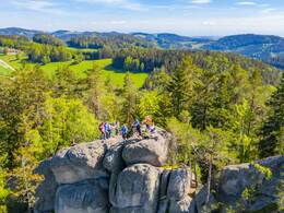
Herzogreitherfelsenweg Nr. 06
Starting place: 4294 St. Leonhard bei Freistadt
Destination: 4294 St. Leonhard bei Freistadt
Hauptstraße 9
4294 St. Leonhard bei Freistadt
4294 St. Leonhard bei Freistadt

Herzogreitherfelsenweg
The hiking route is designed as an outward and return route. An easily accessible hiking trail leads from the start to the Herzogreitherfelsen. From the Herzogreitherfelsen plateau, enjoy the magnificent panoramic view over the Mühlviertel hills, the foothills of the Alps and, with good visibility, the mountain range from Schneeberg to Dachstein. It is one of the most beautiful vantage points in the entire region. However, the ascent to the summit cross is only possible with the help of an attached steel cable and is not without danger. It is therefore only suitable for children if accompanied by an adult.The Susi Wallner lookout point is located along the way, from where you have an impressive view. The key is available at the inns in St. Leonhard.
A little further along the path is the 200-year-old gypsy beech tree. Even before the war, but mainly after 1945, gypsies travelled through the village and sold their wares by the beech tree.
Refreshment stops in the village centre - GH Schwarz (closed on Mondays), GH Janko (closed on Tuesdays and Mondays), Café Konditorei Honeder.
Starting place: 4294 St. Leonhard bei Freistadt
Destination: 4294 St. Leonhard bei Freistadt
duration: 2h 0m
length: 5,0 km
Altitude difference (uphill): 38m
Altitude difference (downhill): 122m
Lowest point: 725m
Highest point: 814m
difficulty: easy
condition: medium
panoramic view: Great panorama
Paths covering:
Hiking trail
Starting point: The starting point for all hiking trails is at the municipal office.
further information:
- Possible accommodation
The Herzogreitherfelsenweg can be hiked at any time.
Accessibility / arrival
by car:
A7 Mühlkreisautobahn direction Freistadt - B124 Königswiesener Straße - left onto L1472 Gutauer Straße to St. Leonhard
- Suitable for groups
- Suitable for seniors
- Suitable for single travelers
- Suitable for families
- Suitable for couples
- Suitable for children
- Spring
- Summer
- Autumn
Please get in touch for more information.
Hauptstraße 9
4294 St. Leonhard bei Freistadt
Phone +43 7952 8255
E-Mail gemeinde@st-leonhard.ooe.gv.at
Web www.stleonhard.at
http://www.stleonhard.at


