Kempfendorfer Berg


- pets allowed
- culinary interesting
- culturally interesting
- Flatly
Interactive elevation profile
Create PDF
Tour-Details
Path number: N2
Starting place: 4212 Neumarkt im Mühlkreis
Destination: 4212 Neumarkt im Mühlkreis
duration: 2h 52m
length: 9,1 km
Altitude difference (uphill): 311m
Altitude difference (downhill): 310m
Lowest point: 608m
Highest point: 720m
difficulty: difficult
condition: medium
panoramic view: Great panorama
Paths covering:
Asphalt, Hiking trail
powered by TOURDATA
The Kempfendorf circular trail leads along the historic salt road through idyllic forests The hiking trail leads along the historic Salzstraße and Bindergasse towards Tannberg. Through an idyllic wooded area you reach the Hager Berg, from where there is a marvellous view of Neumarkt. After crossing the Kefermarkter district road, follow the goods road past the Krempl houses to the Oberdorfer farm.
After a short stretch on the right, you reach the Dingdorf farm track again.
We recommend a detour to the "Dingdorfer Stürberl" (approx. 1.5 km), which is open from Thursday to Sunday. On the way there, hikers can enjoy a magnificent view of Weinberg Castle and the romantic Feldaisttal valley. The hiking trail crosses the goods road and then leads across meadows and through the forest up to the 729 metre high Kempfendorfer Berg.
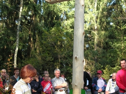
A wooden cross, erected jointly by Neumarkt and Hagenberg hiking enthusiasts, invites you to linger.
After the descent, you reach the village of Au, which has developed into a popular residential area in recent years.
The route leads back to the starting point past the Matzelsdorf fire station to the Hager farm and the Hagerweg.
- Suitable for groups
- Suitable for schools
- Pets allowed
- Summer
- Autumn
Please get in touch for more information.
Marktplatz 1
4212 Neumarkt im Mühlkreis
Phone +43 7941 8255
E-Mail gemeinde@neumarkt-muehlkreis.ooe.gv.at
Web www.neumarkt-muehlkreis.ooe.gv.at
http://www.neumarkt-muehlkreis.ooe.gv.at
Interactive elevation profile
Create PDF
Tour-Details
Path number: N2
Starting place: 4212 Neumarkt im Mühlkreis
Destination: 4212 Neumarkt im Mühlkreis
duration: 2h 52m
length: 9,1 km
Altitude difference (uphill): 311m
Altitude difference (downhill): 310m
Lowest point: 608m
Highest point: 720m
difficulty: difficult
condition: medium
panoramic view: Great panorama
Paths covering:
Asphalt, Hiking trail
powered by TOURDATA

