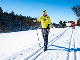
Nußbachtalloipe
There are three different lengths of cross-country skiing trails available. On the one hand, there is the 4.5 km sports ground circuit, the 14 km Nußbachtal trail and the 18 km Mayrhof trail. The starting point for all three trails is at the sports ground, which is easy to find even for people unfamiliar with the area.
Paths covering:
further information:
- Flatly
Details - Trail
- Type of Nordic skiing run: Classic style
Exit Linz, continue on Mühlkreis motorway/A7/E55
exit Mühlkreis motorway/A7/E55, continue on Mühlkreis motorway/A7/E55
enter Bad Zell, continue on Linzer Straße/B124
exit Bad Zell, Continue on Auf der Au/B124
Turn right onto Dorfstraße/B124
Turn left onto Hauptstraße/B124
Turn right onto Hauptstraße/B124
Turn left onto Königswiesener-Bundesstraße/B124
Turn right onto Linzer Straße/B124
Turn left onto Markt
- Deep winter
Please get in touch for more information.
4280 Königswiesen
Phone +43 7955 6255
mobile +43 664 9159128
Fax machine +43 7955 6255 - 32
E-Mail marktgemeinde@koenigswiesen.at
Web www.koenigswiesen.at
Web aktivwelt.at/aktivwelt/front_conten…
http://aktivwelt.at/aktivwelt/front_content.php?idcat=97


