Jaidhauser-Viewpoint – Hubertus Chapel
Path number: 1,201
Starting place: 4573 Hinterstoder
Destination: 4573 Hinterstoder
Hinterstoder 38
4573 Hinterstoder
4573 Hinterstoder

Where the Höss-Panorama-Road in Hinterstoder turns off the Stoder valley country road, you will find a beautiful walking path leading through the forest to the Poppen chapel.
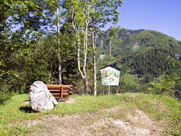
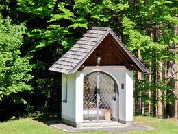
Where the Höss-Panorama-Road in Hinterstoder turns off the Stoder valley country road, you will find a beautiful walking path leading through the forest to the Poppen chapel. On the right side (see sign) a new walking path leads via a range of turns up to another fork in the path. Turn right again and walk along a ridge until you get to the Jaidhauser viewpoint (rubbing station, resting benches), offering a stunning view over the village. Walk back to the fork and continue through the forest on a slightly ascending path for a few minutes until you reach the Hubertus chapel with a lovely view and rest area above the panorama road. Continue down the road for about 1 km to get back to your starting point.Trail Nr: 1, 201
Path number: 1,201
Starting place: 4573 Hinterstoder
Destination: 4573 Hinterstoder
duration: 0h 44m
length: 2,1 km
Altitude difference (uphill): 104m
Altitude difference (downhill): 98m
Lowest point: 582m
Highest point: 668m
difficulty: easy
condition: easy
panoramic view: Individual Views
Paths covering:
Hiking trail
Starting point: Gasthaus Jaidhaus in Hinterstoder
Destination: Gasthaus Jaidhaus in Hinterstoder
further information:
- Flatly
- Board possible
Accessibility / arrival
The starting point is at the beginning of Hoss scenic road / toll.
Parking at the large cable car parking in Hinterstoder.
Most economical season
- Spring
- Summer
- Autumn
Please get in touch for more information.
Hinterstoder 38
4573 Hinterstoder
Phone +43 7564 5263
Fax machine +43 7564 5263 - 30
E-Mail hinterstoder@pyhrn-priel.net
Web www.urlaubsregion-pyhrn-priel.at
https://www.urlaubsregion-pyhrn-priel.at


