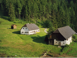
Schafferreith - Bärenalm - Türkenkarscharte


Interactive elevation profile
Create PDF
Tour-Details
Path number: 280
Starting place: 4573 Hinterstoder
Destination: 4573 Hinterstoder
duration: 4h 22m
length: 6,0 km
Altitude difference (uphill): 1.093m
Altitude difference (downhill): 17m
Lowest point: 653m
Highest point: 1.729m
difficulty: medium
condition: medium
panoramic view: Great panorama
Paths covering:
Gravel, Hiking trail
powered by TOURDATA
From the parking area at the Bärenalm in Hinterstoder walk along the road direction Baumschlagerreith for a bit, then turn left along the forest road (trail nr. 18) to Schafferreith.
trail nr. 280 from the end of the parking area walk up a turn on the road, then turn right into the beautiful alpine pasture trail nr. 16, 17 or 280 taking about half an hour to Schafferreith. From Schafferreith continue on trail nr. 280/209 leading steep up towards Bärenalm (hunting lodge). To view the rock formation called “Turk’s Head” you need to continue another half an hour to the Türkenkarscharte. Return along the same trail.Trail-Nr: 16, 17, 209 or 280
Accessibility / arrival
On the main road to the Stodertaler center Hinterstoder for 5 km towards the valley to Bärenalm parking (charges apply).
Parking fees2 hours € 2.00 1 day € 3.00 2 to 7 days € 5.00 Annual ticket € 20.00
Most economical season
- Spring
- Summer
- Autumn
Please get in touch for more information.
Hinterstoder 38
4573 Hinterstoder
Phone +43 7564 5263 - 99
Fax machine +43 7564 5263 - 30
E-Mail hinterstoder@pyhrn-priel.net
Web www.urlaubsregion-pyhrn-priel.at
https://www.urlaubsregion-pyhrn-priel.at
Interactive elevation profile
Create PDF
Tour-Details
Path number: 280
Starting place: 4573 Hinterstoder
Destination: 4573 Hinterstoder
duration: 4h 22m
length: 6,0 km
Altitude difference (uphill): 1.093m
Altitude difference (downhill): 17m
Lowest point: 653m
Highest point: 1.729m
difficulty: medium
condition: medium
panoramic view: Great panorama
Paths covering:
Gravel, Hiking trail
powered by TOURDATA

