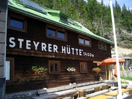
Kasberg mountain via Steyrerhütte (alpine hut)
Starting place: 4571 Klaus an der Pyhrnbahn
Destination: 4645 Grünau im Almtal
From the Brunnental (valley) in Steyrling trail nr. 433 leads through the Katzengraben (ditch) to the managed Steyrerhütte (alpine hut, 1.400m).
Trail-Nr: 433
Walking time: about 2 ½ hrs to the Steyrerhütte and about 3 ½ hrs to the summit of the Kasberg mountain.
Starting place: 4571 Klaus an der Pyhrnbahn
Destination: 4645 Grünau im Almtal
duration: 7h 0m
length: 17,5 km
Altitude difference (uphill): 1.230m
Altitude difference (downhill): 1.230m
Lowest point: 560m
Highest point: 1.747m
difficulty: medium
condition: medium
panoramic view: Great panorama
Paths covering:
Gravel, Hiking trail
Starting point: Brunnental car park in Steyrling
Destination: Brunnental car park in Steyrling
further information:
- Board possible
Accessibility / arrival
From the Klaus or St. Pankraz motorway exit (A9), drive approx. 10 km in the direction of Steyrling.
On arrival in Steyrling, follow the road in the direction of Brunnental.
- Suitable for groups
- Suitable for teenagers
- Suitable for seniors
- Suitable for single travelers
- Suitable for friends
- Suitable for couples
- Summer
- Autumn
Please get in touch for more information.
Bahnhofstraße 2
4580 Windischgarsten
Phone +43 7562 5266
E-Mail info@pyhrn-priel.net
Web www.urlaubsregion-pyhrn-priel.at
https://www.urlaubsregion-pyhrn-priel.at


