Circular Hiking Trail Veichltal
Path number: 23,463,24
Starting place: 4580 Windischgarsten
Destination: 4580 Windischgarsten
Bahnhofstraße 2
4580 Windischgarsten
4580 Windischgarsten

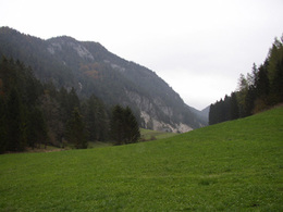
From Windischgarsten, you will hike through the Veichltal around the Sonnwendkogel and Giererkogel and then back to Windischgarsten.
(No. 20) of the forest Radingtales no. 462 on the hill by the Farm "Rumplmayr". On the way no. 20 you come back to Calvary.Hiking path No.: 23, 463, 20
Path number: 23,463,24
Starting place: 4580 Windischgarsten
Destination: 4580 Windischgarsten
duration: 2h 36m
length: 8,8 km
Altitude difference (uphill): 231m
Altitude difference (downhill): 226m
Lowest point: 597m
Highest point: 691m
difficulty: very easy
condition: very easy
panoramic view: Individual Views
Paths covering:
Asphalt, Gravel, Hiking trail
Starting point: Windischgarsten tourist office
Destination: Windischgarsten tourist office
further information:
- Flatly
- Board possible
Details - hiking
- cleared winter hiking path
Accessibility / arrival
West motorway A1 - exit Voralpenkreuz on the A9 (Pyhrnautobahn) direction Graz - exit Roßleithen / Windischgarsten
Most economical season
- Spring
- Summer
- Autumn
Please get in touch for more information.
Bahnhofstraße 2
4580 Windischgarsten
Phone +43 7562 5266
Fax machine +43 7562 5266 - 10
E-Mail info@pyhrn-priel.net
Web www.urlaubsregion-pyhrn-priel.at
https://www.urlaubsregion-pyhrn-priel.at


