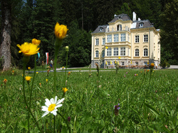
Giererkogel Mountain – Sonnwendkogel Mountain
Path number: 20,23
Starting place: 4580 Windischgarsten
Destination: 4575 Roßleithen
From Windischgarsten, hike via Rettenbach to the Giererkogel and continue to the Sonnwendkogel then back!
The starting point is the Tourist Information in the main road 28 - between this House and the Cafe Grass Ecker, turn into the Fischergasse, go over the bridge of Dambach and follow the signs that will lead subsequently into the valley at the Salza along creek. Passing the stud "Moar im Hof", you forward the road (no. 24) into the Veichltal. A very good walk gravel road leads you along the quarry past a small idyllic pond.Follow up Rettenbach where you turn the trail number 20 on the trail number 23 to Giererkogel right. From Giererkogel you walk on the road next to the Sonnwend Kogel. From there you go to the National Park Lodge Villa Sonnwend and return to Windischgarsten.
Trail-Number: 23
Path number: 20,23
Starting place: 4580 Windischgarsten
Destination: 4575 Roßleithen
duration: 2h 23m
length: 8,1 km
Altitude difference (uphill): 204m
Altitude difference (downhill): 204m
Lowest point: 597m
Highest point: 694m
difficulty: easy
condition: easy
panoramic view: Great panorama
Paths covering:
Asphalt, Gravel, Hiking trail
Starting point: Former tannery Purgleitner in Windischgarsten
further information:
- Flatly
- Board possible
Accessibility / arrival
by car:
Motorway A1 - exit Voralpenkreuz on the A9 (Pyhrnautobahn) direction Graz - exit Roßleithen / Windischgarsten
by train:
Hauptbahnhof Linz - Windischgarsten
Graz - Selzthal - Windischgarsten
Most economical season
- Summer
Please get in touch for more information.
Bahnhofstraße 2
4580 Windischgarsten
Phone +43 7562 5266
Fax machine +43 7562 5266 - 10
E-Mail info@pyhrn-priel.net
Web www.urlaubsregion-pyhrn-priel.at
https://www.urlaubsregion-pyhrn-priel.at


