Bannholzmauer
4580 Windischgarsten

Hike from the Wurbauerkogel to the Bannholz wall and back to the starting point.
Hiking trails: 5, 8
Paths covering:
further information:
- Board possible
April till October
By foot:
Opposite the Windischgarsten town hall, turn into Kühbergstraße. Cross the Dambach stream and after 200 metres you will reach the valley station of the Wurbauerkogel chairlift.
You can either take the chairlift to the Wurbauerkogel or follow the hiking trail that takes you uphill to the right of the valley station for about 1 hour.
By car:
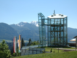
Drive from the centre of Windischgarsten in the direction of Rosenau. After approx. 2 km, after the Schafflmühle, turn left. At the top, keep left and you will arrive directly at the Klettersteigpark Bannholzmauer car park. (47.726435, 14.347618) It is 600 m to the mountain station.
- Summer
- Autumn
Please get in touch for more information.
Bahnhofstraße 2
4580 Windischgarsten
Phone +43 7562 5266
E-Mail info@pyhrn-priel.net
Web www.urlaubsregion-pyhrn-priel.at/


