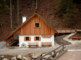
Fraitgraben
Path number: 30
Starting place: 4581 Rosenau am Hengstpaß
Destination: 4580 Edlbach
Bahnhofstraße 2
4580 Windischgarsten
4580 Windischgarsten

From the Hengst Pass road, hike through the Fraitgraben to Ramitscheder Mill, and via the Mitterweng elementary school to Feriengasthaus Grundner in Edlbach.
Hengstpassstraße (pass road) - Haselreith (bus stop) – to the waterfall – continue uphills – Stanglmühle (mill) – Flinderlmühle (mill) – Volksschule Mitterweng (primary school)– GH Grundner (inn), Edlbach (bus stop)Trail-Nr: 30
Path number: 30
Starting place: 4581 Rosenau am Hengstpaß
Destination: 4580 Edlbach
duration: 1h 48m
length: 6,1 km
Altitude difference (uphill): 157m
Altitude difference (downhill): 138m
Lowest point: 640m
Highest point: 818m
difficulty: easy
condition: easy
panoramic view: No view
Paths covering:
Asphalt, Hiking trail
Starting point: Before Rosenau Hengstpass at the Hengstpass-country road at the bus stop Haselreith is the starting point.
Destination: GH Grundner in Edlbach
further information:
- Board possible
Accessibility / arrival
Windischgarsten take the stallion pass the road towards Rosenau. About 1 kilometer after the turn direction Wurbauerkogel right you will find a parking lot where the trail leads off!
Most economical season
- Spring
- Summer
- Autumn
Please get in touch for more information.
Bahnhofstraße 2
4580 Windischgarsten
Phone +43 7562 5266
Fax machine +43 7562 5266 - 10
E-Mail info@pyhrn-priel.net
Web www.urlaubsregion-pyhrn-priel.at
https://www.urlaubsregion-pyhrn-priel.at


