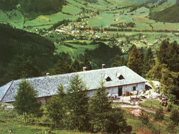
Alpine Pasture Trail from Rohrauerhaus via Hofalm to Gowilalm
Path number: 618
Starting place: 4582 Spital am Pyhrn
Destination: 4582 Spital am Pyhrn
Stiftsplatz 1
4582 Spital am Pyhrn
4582 Spital am Pyhrn

The Almenhöhenweg leads you from the Rohrauerhaus via the Hofalm with a magnificent panorama to the Gowilalm.
The hiking route will reward you with wonderful panoramic views.
Please take into account the arrival and descent times to the Rohrauerhaus and the Gowilalm:
Bosruckhütte car park - Rohrauerhaus: 1 h
Gowilalm - Goslitzbauer-Singerskogel car park: 1.25 h
If required, contact Taxi Sonnleitner.
As a holiday guest you enjoy the rates of the hiking taxi.
Path number: 618
Starting place: 4582 Spital am Pyhrn
Destination: 4582 Spital am Pyhrn
duration: 3h 18m
length: 6,7 km
Altitude difference (uphill): 557m
Altitude difference (downhill): 524m
Lowest point: 1.081m
Highest point: 1.419m
difficulty: medium
condition: medium
panoramic view: Great panorama
Paths covering:
Hiking trail
Starting point: Rohrauerhaus (47.640429, 14.390531)
Destination: Goslitzbauer-Singerskogel car park, Oberweng (47.687240, 14.375974)
further information:
- Possible accommodation
- Board possible
Accessibility / arrival
The easiest way to get there is to get to the car park at the Bosruckhütte. From there you hike to the starting point, the Rohrauerhaus! (1 h) (47.639414, 14.366454)
Most economical season
- Spring
- Summer
- Autumn
Please get in touch for more information.
Stiftsplatz 1
4582 Spital am Pyhrn
Phone +43 7563 249
E-Mail spital@pyhrn-priel.net
Web www.urlaubsregion-pyhrn-priel.at
https://www.urlaubsregion-pyhrn-priel.at


