To the “Five Lindens”
Starting place: 4582 Spital am Pyhrn
Destination: 4582 Spital am Pyhrn
Stiftsplatz 1
4582 Spital am Pyhrn
4582 Spital am Pyhrn

Loop to the smaller monuments of Spital am Pyhrn. On this path, you will come across the old scythe makers’ guild, which was important for the economic and cultural development of our valley.
You start this circular walk with a visit to the baroque former collegiate church of Spital am Pyhrn, the Dom am Pyhrn.Afterwards you walk out of the monastery through the inner courtyard and turn left at the car park to the right to the monastery pond and into Anzwiesenallee. At the end of the avenue, turn right over the bridge and follow the road to the left.
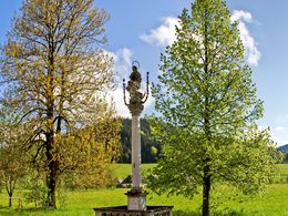
After about 250 metres, you will come to the Mariensäule on the right-hand side.
The Mariensäule was donated in 1727 by the scythe factory couple Georg and Susanna Clara Hirzenberger.
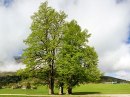
Now continue along the road, past the transformer station and you will come to the five lime trees. You can't miss them, on the left-hand side of the road are these five lime trees alone and below them the box column erected in 1845.
Continue along the road past the Edthofer cross to Schlagedl. Opposite the Schlagedl holiday farm is the chapel wayside shrine, renovated in 1985 and known as the Schlagedl Chapel. It is said that 35 farmers were buried here during the Thirty Years' War.
Now follow the road towards Gleinkersee, pass under the motorway and turn left uphill at the crossroads. At the crossroads towards Roßleithen you will find the Erlerkapelle chapel. The chapel, built in 1834, is also known as the Pyhrnerkogel Chapel.
You do not now walk down the road to Roßleithen, but turn right to the Pyhrnerkogel holiday farm. Now walk along the road to its end and then continue along the dirt track until you come to a road again, which you follow straight ahead until you come to the Seebachhof bus stop. Here you will find the Reitbauern Chapel, built in 1860.
At the main road, turn right, past the sawmill and after the bridge, but before the motorway bridge, turn right to the end of the road and then take the field path along the stream. When you reach the road again, turn left and then left under the motorway and immediately right again towards DANA.
At the next farmhouse, you will see the block pillar Tischler in der Au. Now continue to the DANA door factory. Turn left immediately before it and then right at the end of the factory and follow the road across Garstner Eck to the railway subway. Go through the subway on the right and then immediately right again. After about 500 metres you come to the main road and turn right towards Spital am Pyhrn.
Shortly afterwards you will find the horseshoe chapel on the main road. If you continue walking, you will reach the Hofbauerkapelle chapel just a short time later, opposite Gasthaus Grundner. Turn right there and continue along the railway to the centre of Spital am Pyhrn and your starting point.
Starting place: 4582 Spital am Pyhrn
Destination: 4582 Spital am Pyhrn
duration: 5h 12m
length: 19,4 km
Altitude difference (uphill): 254m
Altitude difference (downhill): 254m
Lowest point: 577m
Highest point: 744m
difficulty: medium
condition: medium
panoramic view: Individual Views
Paths covering:
Asphalt, Gravel
Starting point: Collegiate Church in the center of Spital am Pyhrn
Destination: Collegiate Church in the center of Spital am Pyhrn
further information:
- Flatly
- Board possible
Accessibility / arrival
Parking in the town centre on Stiftsplatz square in Spital am Pyhrn.
Most economical season
- Spring
- Summer
- Autumn
Please get in touch for more information.
Stiftsplatz 1
4582 Spital am Pyhrn
Phone +43 7563 249
E-Mail spital@pyhrn-priel.net
Web www.urlaubsregion-pyhrn-priel.at
https://www.urlaubsregion-pyhrn-priel.at


