Hochsteinalm in Traunkirchen
4801 Traunkirchen

Starting point: Mühlbachberg parking lot
Difficulty: difficult
Trail conditions: gravel, asphalt
Route length: 3,5 km
Duration: 1 hour
Max. Slope: 11%.
Altitude gain: 200 m
Barrier-free WC: Yes
Refreshment stop: Yes
Special feature: Suitable for baby carriages
Approach to the parking lot Mühlbachberg. From there you hike on a very well prepared steadily rising (average 7%) forest road to the Hochsteinalm. The last part to the alp is asphalted, but at the same time also the steepest section with 11% incline. At the top, a rustic inn with a barrier-free toilet awaits you.
The hike to Hochsteinalm is only recommended for experienced wheelchair users plus 2 helpers, E-drive or Swiss Track. There is a quaint inn with a barrier-free WC.
Highlights:
You can feed various animals (alpacas, goats, sheep).
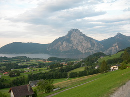
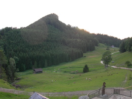
The Hochsteinalm is on a hill in a valley. The large garden with stunning views of the mountains "Höllengebirge" and the Brunnkogel invites you to stop. Specialties from the highlands and a hearty beef and lamb roast and homemade Pofesen are on our menu.
For younger guests there is a playground in sight of the garden and lots of pets.
Paths covering:
further information:
- culinary interesting
- Possible accommodation
- Board possible
Details - hiking
- cleared winter hiking path
daily open
Monday: closed
Holiday: November
bus travel
Buses over 3.4 meters height:
B145 Gmunden - Altmünster - Neukirchen 500 meters from the sports field - turn left towards Traunkirchen - Station - Gasthof Annerlhof 20 meters to the right - mountain road 4km - first parking place (field) on the left - no reverse option above - Allow about 10 minutes longer.
Buses and cars below 3.4 meters height:
B145 - Gmunden - Altmünster - Winkl - after fire department 50m right - signposted.
- Parking space: 40
- All weather
- Suitable for groups
- Suitable for schools
- Suitable for kids (0 - 14 Year)
- Suitable for kids (all ages)
- Suitable for pushchairs
- Pets allowed
- Suitable for single travelers
- Suitable for families
- Suitable for friends
- Suitable for children
- Spring
- Summer
- Autumn
- Early winter
- Deep winter
Somewhat suitable for wheelchairs: Assistance is sometimes necessary. The measurements do not (fully) conform to the legally stipulated ÖNORM.
- Toilet facility for disabled people
Hochsteinalm 1
4801 Traunkirchen
Phone +43 664 9875221
E-Mail info@hochsteinalm.at
Web www.hochsteinalm.at


